IMAGES TAKEN NEAR TO
London Road, TUNBRIDGE WELLS, TN4 0PY
Introduction
This page details the photographs taken nearby to London Road, TN4 0PY by members of the Geograph project.
The Geograph project started in 2005 with the aim of publishing, organising and preserving representative images for every square kilometre of Great Britain, Ireland and the Isle of Man.

There are currently over 7.5m images from over14,400 individuals and you can help contribute to the project by visiting https://www.geograph.org.uk
Image Map
Images are licensed for reuse under creativecommons.org/licenses/by-sa/2.0
Notes
- Clicking on the map will re-center to the selected point.
- The higher the marker number, the further away the image location is from the centre of the postcode.
Image Listing (575 Images Found)
Images are licensed for reuse under creativecommons.org/licenses/by-sa/2.0
Image
Details
Distance
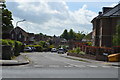
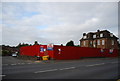
4
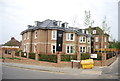
Wellington Gardens
A new development on an old petrol filling station.
Image: © N Chadwick
Taken: 17 May 2014
0.01 miles
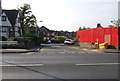
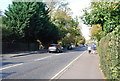
6
Site of a former filling station, London Rd, Southborough
Image: © N Chadwick
Taken: 17 Oct 2009
0.02 miles
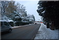
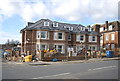
7
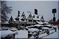
The Weavers, Southborough
A 16th century Wealden Hall. Grade II listed. http://www.britishlistedbuildings.co.uk/en-169328-weaver-s-restaurant-southborough Converted to a bar and restaurant.
Image: © N Chadwick
Taken: 1 Dec 2010
0.02 miles