IMAGES TAKEN NEAR TO
Martletts, BEXHILL-ON-SEA, TN40 1TJ
Introduction
This page details the photographs taken nearby to Martletts, TN40 1TJ by members of the Geograph project.
The Geograph project started in 2005 with the aim of publishing, organising and preserving representative images for every square kilometre of Great Britain, Ireland and the Isle of Man.

There are currently over 7.5m images from over14,400 individuals and you can help contribute to the project by visiting https://www.geograph.org.uk
Image Map
Images are licensed for reuse under creativecommons.org/licenses/by-sa/2.0
Notes
- Clicking on the map will re-center to the selected point.
- The higher the marker number, the further away the image location is from the centre of the postcode.
Image Listing (25 Images Found)
Images are licensed for reuse under creativecommons.org/licenses/by-sa/2.0
Image
Details
Distance
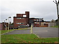
4
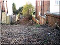
Entrance to development site, Dorset Road
Entrance to a brownfield land housing development site behind 120-122 Dorset Road, Bexhill.
Image: © Patrick Roper
Taken: 9 Dec 2011
0.10 miles
7
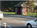
Bus Shelter, De La Warr Road, Bexhill-on-Sea
Image: © Bill Johnson
Taken: 10 Feb 2008
0.14 miles
10
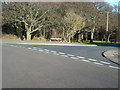
Retained Woodland, Bexhill-on-Sea
This piece of woodland was retained when the area surrounding was developed for residential purposes.
Image: © Bill Johnson
Taken: 10 Feb 2008
0.16 miles