IMAGES TAKEN NEAR TO
Sutton Place, BEXHILL-ON-SEA, TN40 1PH
Introduction
This page details the photographs taken nearby to Sutton Place, TN40 1PH by members of the Geograph project.
The Geograph project started in 2005 with the aim of publishing, organising and preserving representative images for every square kilometre of Great Britain, Ireland and the Isle of Man.

There are currently over 7.5m images from over14,400 individuals and you can help contribute to the project by visiting https://www.geograph.org.uk
Image Map (Loading...)


Getting Data...Please wait
Leaflet Map data © OpenStreetMap
Images are licensed for reuse under creativecommons.org/licenses/by-sa/2.0
Notes
- Clicking on the map will re-center to the selected point.
- The higher the marker number, the further away the image location is from the centre of the postcode.
Image Listing (106 Images Found)
Images are licensed for reuse under creativecommons.org/licenses/by-sa/2.0
Image
Details
Distance
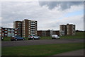
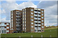
4
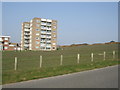
Flats at Galley Hill
at the eastern end of Bexhill
Image: © Paul Gillett
Taken: 25 Mar 2011
0.04 miles
5
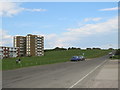
De La Warr Parade, Bexhill
De La Warr Parade heading eastwards out of Bexhill-on-Sea. This road forms part of National Cycle Network route 2.
Image: © Malc McDonald
Taken: 25 May 2019
0.06 miles
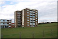
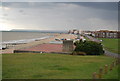
7
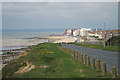
De La Warr Parade
From the top of a short section of cliff at Galley Hill, looking towards beach and apartments.
Image: © Oast House Archive
Taken: 31 May 2010
0.06 miles
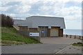
8
View from Galley Hill
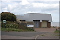
The pumping station is in the foreground, Beachy Head in the background.
Image: © N Chadwick
Taken: 20 Aug 2014
0.07 miles