IMAGES TAKEN NEAR TO
De La Warr Parade, BEXHILL-ON-SEA, TN40 1AY
Introduction
This page details the photographs taken nearby to De La Warr Parade, TN40 1AY by members of the Geograph project.
The Geograph project started in 2005 with the aim of publishing, organising and preserving representative images for every square kilometre of Great Britain, Ireland and the Isle of Man.

There are currently over 7.5m images from over14,400 individuals and you can help contribute to the project by visiting https://www.geograph.org.uk
Image Map
Images are licensed for reuse under creativecommons.org/licenses/by-sa/2.0
Notes
- Clicking on the map will re-center to the selected point.
- The higher the marker number, the further away the image location is from the centre of the postcode.
Image Listing (104 Images Found)
Images are licensed for reuse under creativecommons.org/licenses/by-sa/2.0
Image
Details
Distance
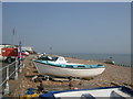
3
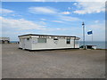
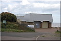
Bexhill Sea Angling Clubhouse
The clubhouse of the Bexhill Sea Angling Club, on the seafront at Bexhill-on-Sea.
Image: © Malc McDonald
Taken: 25 May 2019
0.00 miles
4
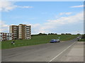
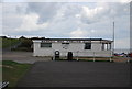
De La Warr Parade, Bexhill
De La Warr Parade heading eastwards out of Bexhill-on-Sea. This road forms part of National Cycle Network route 2.
Image: © Malc McDonald
Taken: 25 May 2019
0.01 miles
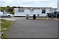
8
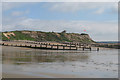
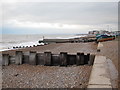
Beach near Galley Hill
See more sizes for wider panorama.
Image: © Oast House Archive
Taken: 31 May 2010
0.04 miles