IMAGES TAKEN NEAR TO
Orchard Rise, TUNBRIDGE WELLS, TN3 9RU
Introduction
This page details the photographs taken nearby to Orchard Rise, TN3 9RU by members of the Geograph project.
The Geograph project started in 2005 with the aim of publishing, organising and preserving representative images for every square kilometre of Great Britain, Ireland and the Isle of Man.

There are currently over 7.5m images from over14,400 individuals and you can help contribute to the project by visiting https://www.geograph.org.uk
Image Map (Loading...)


Getting Data...Please wait
Leaflet Map data © OpenStreetMap
Images are licensed for reuse under creativecommons.org/licenses/by-sa/2.0
Notes
- Clicking on the map will re-center to the selected point.
- The higher the marker number, the further away the image location is from the centre of the postcode.
Image Listing (289 Images Found)
Images are licensed for reuse under creativecommons.org/licenses/by-sa/2.0
Image
Details
Distance
2
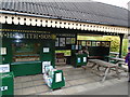
Groombridge Station
On the Spa Valley Railway
Image: © Paul Gillett
Taken: 1 Jul 2017
0.02 miles
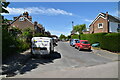
9
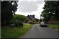
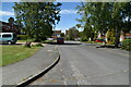
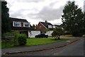
Gromenfield, Groombridge
Small cul-de-sac between the railway and Corseley Road.
Image: © Simon Carey
Taken: 12 Jan 2008
0.07 miles
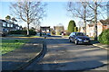
10
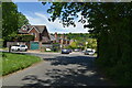
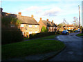
Houses on Broad Oak, Groombridge
Cul de sac in this small village that straddles the East Sussex, Kent border
Image: © N Chadwick
Taken: 27 Aug 2009
0.09 miles