IMAGES TAKEN NEAR TO
Corseley Road, TUNBRIDGE WELLS, TN3 9RH
Introduction
This page details the photographs taken nearby to Corseley Road, TN3 9RH by members of the Geograph project.
The Geograph project started in 2005 with the aim of publishing, organising and preserving representative images for every square kilometre of Great Britain, Ireland and the Isle of Man.

There are currently over 7.5m images from over14,400 individuals and you can help contribute to the project by visiting https://www.geograph.org.uk
Image Map (Loading...)


Getting Data...Please wait
Leaflet Map data © OpenStreetMap
Images are licensed for reuse under creativecommons.org/licenses/by-sa/2.0
Notes
- Clicking on the map will re-center to the selected point.
- The higher the marker number, the further away the image location is from the centre of the postcode.
Image Listing (283 Images Found)
Images are licensed for reuse under creativecommons.org/licenses/by-sa/2.0
Image
Details
Distance
1
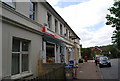
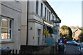
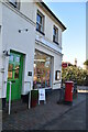
Spar, Groombridge
Village shop in this village that straddles the Kent, East Sussex border
Image: © N Chadwick
Taken: 27 Aug 2009
0.01 miles
2

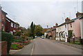
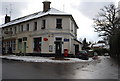
Station Road, Groombridge
The major shopping district of the village with a post office, bakery and general stores all next to each other. Station Road heads straight ahead whilst Corseley Road is to the right. Most of this part of Groombridge was developed after the arrival of the railway.
Image: © Simon Carey
Taken: 12 Jan 2008
0.01 miles
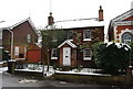
6
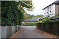
Terrace of houses, Springfield Rd, Groombridge
Image: © N Chadwick
Taken: 27 Aug 2009
0.04 miles