IMAGES TAKEN NEAR TO
Eridge Road, TUNBRIDGE WELLS, TN3 9NN
Introduction
This page details the photographs taken nearby to Eridge Road, TN3 9NN by members of the Geograph project.
The Geograph project started in 2005 with the aim of publishing, organising and preserving representative images for every square kilometre of Great Britain, Ireland and the Isle of Man.

There are currently over 7.5m images from over14,400 individuals and you can help contribute to the project by visiting https://www.geograph.org.uk
Image Map
Images are licensed for reuse under creativecommons.org/licenses/by-sa/2.0
Notes
- Clicking on the map will re-center to the selected point.
- The higher the marker number, the further away the image location is from the centre of the postcode.
Image Listing (29 Images Found)
Images are licensed for reuse under creativecommons.org/licenses/by-sa/2.0
Image
Details
Distance
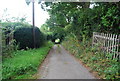
3
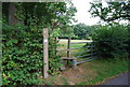
Stile, Eridge Rd
The Tunbridge Wells Circular Path heads east from here to Eridge Green
Image: © N Chadwick
Taken: 27 Aug 2009
0.07 miles
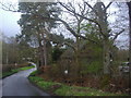
4
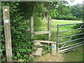
Tunbridge Wells Circular on Park Corner Road
The long distance path leads towards Eridge, via fields from this stile.
Image: © David Anstiss
Taken: 20 Jul 2009
0.07 miles
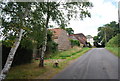
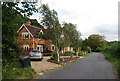
8
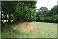
Tunbridge Wells Circular path follows a field edge east of Park Corner
Image: © N Chadwick
Taken: 27 Aug 2009
0.11 miles