IMAGES TAKEN NEAR TO
Sand Hill Lane, TUNBRIDGE WELLS, TN3 9LR
Introduction
This page details the photographs taken nearby to Sand Hill Lane, TN3 9LR by members of the Geograph project.
The Geograph project started in 2005 with the aim of publishing, organising and preserving representative images for every square kilometre of Great Britain, Ireland and the Isle of Man.

There are currently over 7.5m images from over14,400 individuals and you can help contribute to the project by visiting https://www.geograph.org.uk
Image Map (Loading...)


Getting Data...Please wait
Leaflet Map data © OpenStreetMap
Images are licensed for reuse under creativecommons.org/licenses/by-sa/2.0
Notes
- Clicking on the map will re-center to the selected point.
- The higher the marker number, the further away the image location is from the centre of the postcode.
Image Listing (35 Images Found)
Images are licensed for reuse under creativecommons.org/licenses/by-sa/2.0
Image
Details
Distance
2
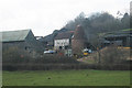
Unconverted Oast House at Mead Farm, Sandhill Lane, Eridge, East Sussex
Single round kiln oast house, missing cowl.
Image: © Oast House Archive
Taken: 2 Mar 2010
0.07 miles
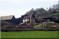
4
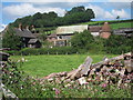
Mead Farm
Traditional farmstead off Sand Hill Lane, including an unconverted disused oast house.
Image: © Oast House Archive
Taken: 22 Jul 2011
0.08 miles
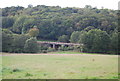
5
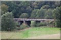
Railway bridge near Stitches Farm
The Uckfield line.
Image: © N Chadwick
Taken: 17 Oct 2010
0.15 miles
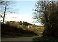
6
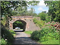
Railway Bridge 1026
Car ahead turning into Sand Hill Lane.
Image: © Oast House Archive
Taken: 22 Jul 2011
0.15 miles
7
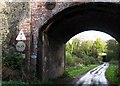
Redgate Mill Lane, Boarshead
The bridge carries the Uckfield railway line, but under the bridge and in the distance there is another bridge which carried the line to Eastbourne. Sadly, this line is long closed, but the Uckfield line lives on.
Image: © nick macneill
Taken: 2 Nov 2012
0.15 miles
9
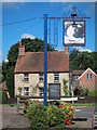
Half Moon Inn sign and Bakers Corner
Looking across the pub sign to a grade II listed http://list.english-heritage.org.uk/resultsingle.aspx?uid=1353350 house on School Hill at the junction with Battle Road.
Image: © Oast House Archive
Taken: 22 Jul 2011
0.15 miles