IMAGES TAKEN NEAR TO
High Rocks Lane, TUNBRIDGE WELLS, TN3 9JJ
Introduction
This page details the photographs taken nearby to High Rocks Lane, TN3 9JJ by members of the Geograph project.
The Geograph project started in 2005 with the aim of publishing, organising and preserving representative images for every square kilometre of Great Britain, Ireland and the Isle of Man.

There are currently over 7.5m images from over14,400 individuals and you can help contribute to the project by visiting https://www.geograph.org.uk
Image Map (Loading...)


Getting Data...Please wait
Leaflet Map data © OpenStreetMap
Images are licensed for reuse under creativecommons.org/licenses/by-sa/2.0
Notes
- Clicking on the map will re-center to the selected point.
- The higher the marker number, the further away the image location is from the centre of the postcode.
Image Listing (266 Images Found)
Images are licensed for reuse under creativecommons.org/licenses/by-sa/2.0
Image
Details
Distance
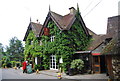
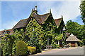
4
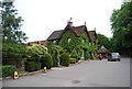
High Rocks Inn
Grade II listed. https://historicengland.org.uk/listing/the-list/list-entry/1028345
Image: © N Chadwick
Taken: 27 Mar 2020
0.01 miles
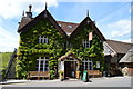
7
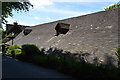
High Rocks Hotel (closed)
Closed at present due to the COVID-19 lockdown.
Grade II listed. https://historicengland.org.uk/listing/the-list/list-entry/1028345
Image: © N Chadwick
Taken: 18 May 2020
0.01 miles
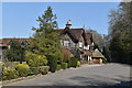
8

The entrance to High Rocks
During the November 2020 lockdown, High Rocks was well and truly closed.
Image: © Marathon
Taken: 7 Nov 2020
0.01 miles