IMAGES TAKEN NEAR TO
Eridge Park, TUNBRIDGE WELLS, TN3 9HA
Introduction
This page details the photographs taken nearby to Eridge Park, TN3 9HA by members of the Geograph project.
The Geograph project started in 2005 with the aim of publishing, organising and preserving representative images for every square kilometre of Great Britain, Ireland and the Isle of Man.

There are currently over 7.5m images from over14,400 individuals and you can help contribute to the project by visiting https://www.geograph.org.uk
Image Map (Loading...)


Getting Data...Please wait
Leaflet Map data © OpenStreetMap
Images are licensed for reuse under creativecommons.org/licenses/by-sa/2.0
Notes
- Clicking on the map will re-center to the selected point.
- The higher the marker number, the further away the image location is from the centre of the postcode.
Image Listing (30 Images Found)
Images are licensed for reuse under creativecommons.org/licenses/by-sa/2.0
Image
Details
Distance
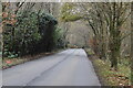
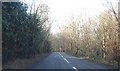
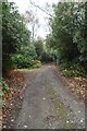
4
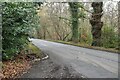
A pedestrian's view of Bunny Lane
Heading west through Whitehill Wood.
Image: © Christine Johnstone
Taken: 2 Aug 2018
0.08 miles
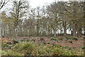
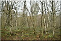
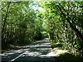
10
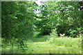
Woodland glade, Bunny Lane near Frant
Taken from Bunny Lane (between the A26 and A267) near Frant, East Sussex
Image: © Martin Coull
Taken: 25 May 2009
0.12 miles