IMAGES TAKEN NEAR TO
Wadhurst Road, TUNBRIDGE WELLS, TN3 9EP
Introduction
This page details the photographs taken nearby to Wadhurst Road, TN3 9EP by members of the Geograph project.
The Geograph project started in 2005 with the aim of publishing, organising and preserving representative images for every square kilometre of Great Britain, Ireland and the Isle of Man.

There are currently over 7.5m images from over14,400 individuals and you can help contribute to the project by visiting https://www.geograph.org.uk
Image Map (Loading...)


Getting Data...Please wait
Leaflet Map data © OpenStreetMap
Images are licensed for reuse under creativecommons.org/licenses/by-sa/2.0
Notes
- Clicking on the map will re-center to the selected point.
- The higher the marker number, the further away the image location is from the centre of the postcode.
Image Listing (36 Images Found)
Images are licensed for reuse under creativecommons.org/licenses/by-sa/2.0
Image
Details
Distance
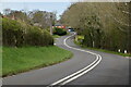
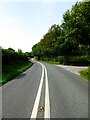
2
B2099 Wadhurst Road, Frant
Towards Wadhurst
Image: © Oast House Archive
Taken: 16 Jun 2009
0.02 miles
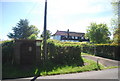
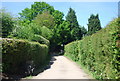
4
Wadhurst Road
The B2099 links the A267 at Sleeches Cross to the A21 north of Hurst Green, serving the large villages of Wadhurst and Ticehurst. This section heads west past Henley Farm.
Image: © Simon Carey
Taken: 26 Jul 2023
0.03 miles
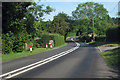
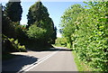
6
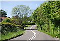
B2099, Wadhurst Road
The B2099 runs between Ticehurst and Frant, both in East Sussex.
Image: © N Chadwick
Taken: 22 May 2010
0.03 miles
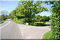
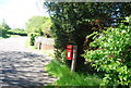
9
B2099 heading north west
The B2099 runs between Ticehurst and Frant, both in East Sussex.
Image: © N Chadwick
Taken: 22 May 2010
0.05 miles