IMAGES TAKEN NEAR TO
The Green, TUNBRIDGE WELLS, TN3 9DN
Introduction
This page details the photographs taken nearby to The Green, TN3 9DN by members of the Geograph project.
The Geograph project started in 2005 with the aim of publishing, organising and preserving representative images for every square kilometre of Great Britain, Ireland and the Isle of Man.

There are currently over 7.5m images from over14,400 individuals and you can help contribute to the project by visiting https://www.geograph.org.uk
Image Map
Images are licensed for reuse under creativecommons.org/licenses/by-sa/2.0
Notes
- Clicking on the map will re-center to the selected point.
- The higher the marker number, the further away the image location is from the centre of the postcode.
Image Listing (173 Images Found)
Images are licensed for reuse under creativecommons.org/licenses/by-sa/2.0
Image
Details
Distance
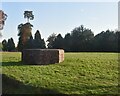
3
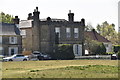
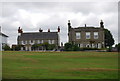
Stone House
Grade II listed. https://historicengland.org.uk/listing/the-list/list-entry/1028343
Image: © N Chadwick
Taken: 24 Apr 2020
0.02 miles
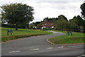
4

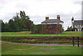
The Green in Frant
The green high point in Frant, East Sussex with houses in the background on Warren Ridge.
Image: © John P Reeves
Taken: 26 Dec 2020
0.03 miles