IMAGES TAKEN NEAR TO
Ninfield Road, BEXHILL-ON-SEA, TN39 5JS
Introduction
This page details the photographs taken nearby to Ninfield Road, TN39 5JS by members of the Geograph project.
The Geograph project started in 2005 with the aim of publishing, organising and preserving representative images for every square kilometre of Great Britain, Ireland and the Isle of Man.

There are currently over 7.5m images from over14,400 individuals and you can help contribute to the project by visiting https://www.geograph.org.uk
Image Map
Images are licensed for reuse under creativecommons.org/licenses/by-sa/2.0
Notes
- Clicking on the map will re-center to the selected point.
- The higher the marker number, the further away the image location is from the centre of the postcode.
Image Listing (28 Images Found)
Images are licensed for reuse under creativecommons.org/licenses/by-sa/2.0
Image
Details
Distance
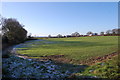
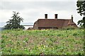
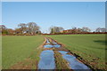
5
Park Field
The name of the field according to Ninfield's 1844 tithe map located to the south west of Ninfield Road, the A269. Pashley Farm is in the distance.
Image: © Simon Carey
Taken: 21 Sep 2019
0.08 miles
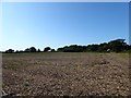
7
Coney Burrow
The name of the field according to Ninfield's 1844 tithe map located to the east of Pashley Farm.
Image: © Simon Carey
Taken: 21 Sep 2019
0.10 miles
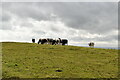
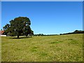
9
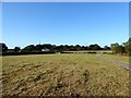
Mount Field
The name of the field according to Ninfield's 1844 tithe map with Pashley Farm Cottages in the distance.
Image: © Simon Carey
Taken: 21 Sep 2019
0.11 miles