IMAGES TAKEN NEAR TO
Freezeland Lane, BEXHILL-ON-SEA, TN39 5JD
Introduction
This page details the photographs taken nearby to Freezeland Lane, TN39 5JD by members of the Geograph project.
The Geograph project started in 2005 with the aim of publishing, organising and preserving representative images for every square kilometre of Great Britain, Ireland and the Isle of Man.

There are currently over 7.5m images from over14,400 individuals and you can help contribute to the project by visiting https://www.geograph.org.uk
Image Map (Loading...)


Getting Data...Please wait
Leaflet Map data © OpenStreetMap
Images are licensed for reuse under creativecommons.org/licenses/by-sa/2.0
Notes
- Clicking on the map will re-center to the selected point.
- The higher the marker number, the further away the image location is from the centre of the postcode.
Image Listing (30 Images Found)
Images are licensed for reuse under creativecommons.org/licenses/by-sa/2.0
Image
Details
Distance

5
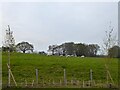
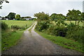
Barn Field
The name of the field according to Bexhill's 1839 tithe map that has been split in two by the construction of Haven Brook Avenue, the A2691. This is the northern portion which abuts Kiteye Wood tot he east.
Image: © Simon Carey
Taken: 30 Apr 2023
0.12 miles