IMAGES TAKEN NEAR TO
Scholars Walk, BEXHILL-ON-SEA, TN39 5GA
Introduction
This page details the photographs taken nearby to Scholars Walk, TN39 5GA by members of the Geograph project.
The Geograph project started in 2005 with the aim of publishing, organising and preserving representative images for every square kilometre of Great Britain, Ireland and the Isle of Man.

There are currently over 7.5m images from over14,400 individuals and you can help contribute to the project by visiting https://www.geograph.org.uk
Image Map
Images are licensed for reuse under creativecommons.org/licenses/by-sa/2.0
Notes
- Clicking on the map will re-center to the selected point.
- The higher the marker number, the further away the image location is from the centre of the postcode.
Image Listing (17 Images Found)
Images are licensed for reuse under creativecommons.org/licenses/by-sa/2.0
Image
Details
Distance
1
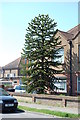
Monkey Puzzle Tree, Southlands Road, Bexhill
Image: © Julian P Guffogg
Taken: 3 May 2013
0.05 miles
2
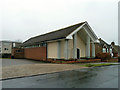
Our Lady of the Rosary church, Sidley
A Roman Catholic place of worship on Southlands Road.
Image: © Robin Webster
Taken: 25 Feb 2012
0.14 miles
6
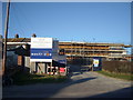
Construction Work, Sidley
The Medical Centre which occupied this site has been demolished and a new Centre is being erected on the site.
Image: © Bill Johnson
Taken: 16 Feb 2008
0.19 miles
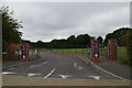
7
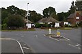
School Exit, Sutherland Avenue, Sidley, East Sussex
Image: © Oast House Archive
Taken: 25 Oct 2008
0.19 miles
8
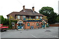
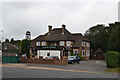
Rose and Crown Pub, Turkey road, Bexhill
Image: © Julian P Guffogg
Taken: 26 Jul 2009
0.19 miles