IMAGES TAKEN NEAR TO
Glovers Lane, BEXHILL-ON-SEA, TN39 5AW
Introduction
This page details the photographs taken nearby to Glovers Lane, TN39 5AW by members of the Geograph project.
The Geograph project started in 2005 with the aim of publishing, organising and preserving representative images for every square kilometre of Great Britain, Ireland and the Isle of Man.

There are currently over 7.5m images from over14,400 individuals and you can help contribute to the project by visiting https://www.geograph.org.uk
Image Map (Loading...)


Getting Data...Please wait
Leaflet Map data © OpenStreetMap
Images are licensed for reuse under creativecommons.org/licenses/by-sa/2.0
Notes
- Clicking on the map will re-center to the selected point.
- The higher the marker number, the further away the image location is from the centre of the postcode.
Image Listing (114 Images Found)
Images are licensed for reuse under creativecommons.org/licenses/by-sa/2.0
Image
Details
Distance
1

Glovers Lane, Sidley
Originally the access rack to Glovers Farm from Sidley Green that has now been swallowed by the urbanisation of Bexhill. To the left are Glovers Cottages whilst beyond is Staverton which I think dates back to the 19th century.
Image: © Simon Carey
Taken: 28 Oct 2019
0.02 miles
2

Glenburn Close, Sidley
A cul de sac off Glovers Lane built around the turn of this century.
Image: © Simon Carey
Taken: 28 Oct 2019
0.02 miles
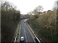
3
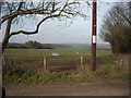
Countryside, Sidley
The significance of this photograph lies in the white notice attached to the telegraph post advising that this site is part of the proposed Bexhill to Hastings Link Road.
If the road building goes ahead the scene will change to one of residential and warehouse facilities.
Image: © Bill Johnson
Taken: 25 Feb 2008
0.03 miles
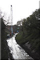
4
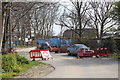
Footpath closed
Footpath and access to Glover's Farm closed whilst the old single width railway bridge is replaced to accommodate the new road.
Image: © Oast House Archive
Taken: 16 Apr 2015
0.04 miles
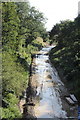
5
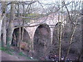
Railway Bridge, Sidley
A bridge on the disused Bexhill to Crowhurst Branch Line.
Image: © Bill Johnson
Taken: 25 Feb 2008
0.06 miles
7
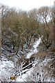
Former railway
This former railway line will become the new Hastings to Bexhill link road, for which clearing has begun.
Image: © Oast House Archive
Taken: 19 Jan 2013
0.06 miles
8
Former railway & Combe Valley Way construction
Compare with Image before it was cleared.
Image: © Oast House Archive
Taken: 12 Aug 2014
0.06 miles
9
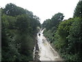
Coombe Valley Way construction
Looking from Glovers Lane bridge.
Image: © Oast House Archive
Taken: 8 Nov 2014
0.06 miles
10
Combe Valley Way
Image: © Oast House Archive
Taken: 19 Dec 2015
0.07 miles