IMAGES TAKEN NEAR TO
Barnhorn Road, BEXHILL-ON-SEA, TN39 4QR
Introduction
This page details the photographs taken nearby to Barnhorn Road, TN39 4QR by members of the Geograph project.
The Geograph project started in 2005 with the aim of publishing, organising and preserving representative images for every square kilometre of Great Britain, Ireland and the Isle of Man.

There are currently over 7.5m images from over14,400 individuals and you can help contribute to the project by visiting https://www.geograph.org.uk
Image Map (Loading...)


Getting Data...Please wait
Leaflet Map data © OpenStreetMap
Images are licensed for reuse under creativecommons.org/licenses/by-sa/2.0
Notes
- Clicking on the map will re-center to the selected point.
- The higher the marker number, the further away the image location is from the centre of the postcode.
Image Listing (13 Images Found)
Images are licensed for reuse under creativecommons.org/licenses/by-sa/2.0
Image
Details
Distance
2
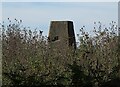
Barnhorn Trigpoint in East Sussex
The Barnhorn Trigpoint in East Sussex is situated just north of the A259 at Hill Farm west of Little Common.
Image: © John P Reeves
Taken: 9 Aug 2022
0.10 miles
3
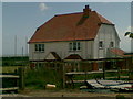
Upper Pound Field
The name of the field according to the 1843 tithe map. The Barn Cottages lies at the end of the field whilst Barnhorn Manor oast can be seen on the very right.
Image: © Simon Carey
Taken: 7 Mar 2010
0.10 miles
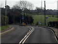
5
Old and New Roads
The old course of the A259 is on the left and is little more than a single track lane that linked the Lamb Inn with Barnhorn. The whole marsh road between Pevensey and this point was straightened between the wars and is now the A259
Image: © Simon Carey
Taken: 7 Mar 2010
0.14 miles
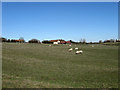
7
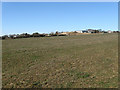
Pound Field Meadow
The name of the field according to the 1843 tithe map. Middle Barn Farm is centre right whilst Hill Farm Cottage is to the right.
Image: © Simon Carey
Taken: 7 Mar 2010
0.15 miles
8
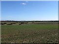
Eleven Acre Pound Field
The name of the field according to the 1843 tithe map. Hooe Level lies at the bottom of the slope whilst the houses of Cooden, the western most suburb of Bexhill, can be seen in the distance.
Image: © Simon Carey
Taken: 7 Mar 2010
0.17 miles
9

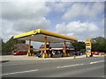
A259 Barnhorn Road passes Jet service station
Image: © Stuart Logan
Taken: 27 May 2012
0.19 miles
10
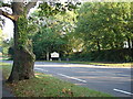
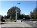
Road
A very quiet moment on the very busy A259 road to Bexhill-on-Sea from Eastbourne, East Sussex.
Image: © Janet Richardson
Taken: 15 Oct 2005
0.20 miles