IMAGES TAKEN NEAR TO
Barnhorn Road, BEXHILL-ON-SEA, TN39 4QA
Introduction
This page details the photographs taken nearby to Barnhorn Road, TN39 4QA by members of the Geograph project.
The Geograph project started in 2005 with the aim of publishing, organising and preserving representative images for every square kilometre of Great Britain, Ireland and the Isle of Man.

There are currently over 7.5m images from over14,400 individuals and you can help contribute to the project by visiting https://www.geograph.org.uk
Image Map
Images are licensed for reuse under creativecommons.org/licenses/by-sa/2.0
Notes
- Clicking on the map will re-center to the selected point.
- The higher the marker number, the further away the image location is from the centre of the postcode.
Image Listing (6 Images Found)
Images are licensed for reuse under creativecommons.org/licenses/by-sa/2.0
Image
Details
Distance
1
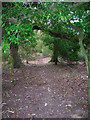
Footpath Bexhill 11b
This rather pleasant walk now starts from the A259 along a short private residential road interestingly named Kites Nest Walk. When did Kites last nest here?
Image: © Robin Webster
Taken: 25 Feb 2012
0.08 miles
2
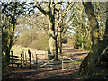
Footpath to Gotham
Links the path from Barnhorn Road, the A259, to Gotham Farm.
Image: © Simon Carey
Taken: 22 Feb 2008
0.17 miles
3
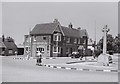
Wheatsheaf Inn, Little Common
The Wheatsheaf Inn and War Memorial taken about 1951.
Image: © Les Whitcomb
Taken: Unknown
0.19 miles
4
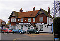
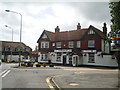
The Wheatsheaf Inn, Little Common, Cooden, Bexhill
This inn was established in the late 18th Century. It was a coaching inn on the busy coast road between Hastings and Pevensey (now the A259) The roads were improved in the early 1800s to assist military traffic along the coast during the time of the Napoleonic threat. A small village grew up around the inn which became known as Little Common.
Image: © Kevin Gordon
Taken: 22 Feb 2009
0.23 miles