IMAGES TAKEN NEAR TO
Fyning Place, BEXHILL-ON-SEA, TN39 4NQ
Introduction
This page details the photographs taken nearby to Fyning Place, TN39 4NQ by members of the Geograph project.
The Geograph project started in 2005 with the aim of publishing, organising and preserving representative images for every square kilometre of Great Britain, Ireland and the Isle of Man.

There are currently over 7.5m images from over14,400 individuals and you can help contribute to the project by visiting https://www.geograph.org.uk
Image Map (Loading...)


Getting Data...Please wait
Leaflet Map data © OpenStreetMap
Images are licensed for reuse under creativecommons.org/licenses/by-sa/2.0
Notes
- Clicking on the map will re-center to the selected point.
- The higher the marker number, the further away the image location is from the centre of the postcode.
Image Listing (6 Images Found)
Images are licensed for reuse under creativecommons.org/licenses/by-sa/2.0
Image
Details
Distance
1
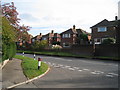
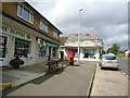
Houses on Peartree Lane, Cooden, East Sussex
Image: © Oast House Archive
Taken: 25 Oct 2008
0.15 miles
2
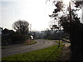
Road Little Common East Sussex
Pear Tree Lane heading south into the village of Little Common which is on the A259
Image: © Janet Richardson
Taken: 24 Jan 2006
0.15 miles
3
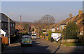
Green Lane, Little Common, Bexhill
This church runs downhill from St Marks Church on White Hill
Image: © Kevin Gordon
Taken: 27 Dec 2008
0.19 miles
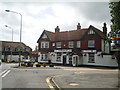
5
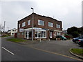
Empty Shop in Peartree Lane, Little Common
Image: © PAUL FARMER
Taken: 15 Mar 2015
0.23 miles