IMAGES TAKEN NEAR TO
Dalehurst Road, BEXHILL-ON-SEA, TN39 4BN
Introduction
This page details the photographs taken nearby to Dalehurst Road, TN39 4BN by members of the Geograph project.
The Geograph project started in 2005 with the aim of publishing, organising and preserving representative images for every square kilometre of Great Britain, Ireland and the Isle of Man.

There are currently over 7.5m images from over14,400 individuals and you can help contribute to the project by visiting https://www.geograph.org.uk
Image Map (Loading...)


Getting Data...Please wait
Leaflet Map data © OpenStreetMap
Images are licensed for reuse under creativecommons.org/licenses/by-sa/2.0
Notes
- Clicking on the map will re-center to the selected point.
- The higher the marker number, the further away the image location is from the centre of the postcode.
Image Listing (9 Images Found)
Images are licensed for reuse under creativecommons.org/licenses/by-sa/2.0
Image
Details
Distance
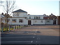
1
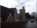
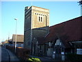
All Saints Parish Church Sidley East Sussex
All Saints Parish Church and All Saints Church of England Primary School in All Saints Lane Sidley a northern suburb of Bexhill-on-Sea
Image: © Janet Richardson
Taken: 22 Mar 2006
0.14 miles
3
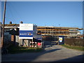
Construction Work, Sidley
The Medical Centre which occupied this site has been demolished and a new Centre is being erected on the site.
Image: © Bill Johnson
Taken: 16 Feb 2008
0.15 miles
4
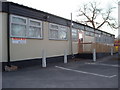
Temporary Medical Centre, Sidley
Whilst the new Medical Centre is being constructed, surgeries continue in this temporary building.
Image: © Bill Johnson
Taken: 16 Feb 2008
0.16 miles
7
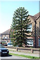
Monkey Puzzle Tree, Southlands Road, Bexhill
Image: © Julian P Guffogg
Taken: 3 May 2013
0.23 miles