IMAGES TAKEN NEAR TO
Grangecourt Drive, BEXHILL-ON-SEA, TN39 4AX
Introduction
This page details the photographs taken nearby to Grangecourt Drive, TN39 4AX by members of the Geograph project.
The Geograph project started in 2005 with the aim of publishing, organising and preserving representative images for every square kilometre of Great Britain, Ireland and the Isle of Man.

There are currently over 7.5m images from over14,400 individuals and you can help contribute to the project by visiting https://www.geograph.org.uk
Image Map (Loading...)


Getting Data...Please wait
Leaflet Map data © OpenStreetMap
Images are licensed for reuse under creativecommons.org/licenses/by-sa/2.0
Notes
- Clicking on the map will re-center to the selected point.
- The higher the marker number, the further away the image location is from the centre of the postcode.
Image Listing (35 Images Found)
Images are licensed for reuse under creativecommons.org/licenses/by-sa/2.0
Image
Details
Distance
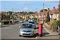
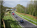
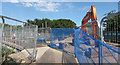
2

Part of Bexhill to Hastings link road
The first section to be opened from A259 towards Sidley. The over bridge at Sidley was still being constructed at this time.
The road had only been open a few days.
Image: © Julian P Guffogg
Taken: 3 Oct 2014
0.10 miles
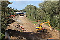
3
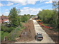
Hastings-Bexhill Link road beginning construction
Reusing a former railway line.
Image: © Oast House Archive
Taken: 12 May 2013
0.10 miles
4
Hastings-Bexhill Link road beginning construction
Reusing a former railway line.
Image: © Oast House Archive
Taken: 12 May 2013
0.10 miles
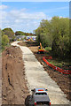
5
Combe Valley Way, Sidley
A completed section of the new road diverting traffic from London Road whilst a Ninfield Road bridge is being replaced.
Image: © Oast House Archive
Taken: 6 May 2015
0.10 miles
6
Combe Valley Way, Sidley
A completed section of the new road diverting traffic from London Road whilst a Ninfield Road bridge is being replaced.
Image: © Oast House Archive
Taken: 6 May 2015
0.10 miles
7
Hastings-Bexhill Link road beginning construction
Reusing a former railway line.
Image: © Oast House Archive
Taken: 12 May 2013
0.10 miles
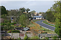
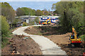
8
Combe Valley Way construction
Seen from the recently opened Woodsgate Park bridge.
Image: © Oast House Archive
Taken: 12 Aug 2014
0.11 miles
9
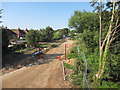
Link Road Construction
View from the temporary bridge over Woodsgate Park.
Image: © Oast House Archive
Taken: 1 Aug 2013
0.11 miles
10
Temporary footbridge, Woodsgate Park
The road is closed whilst a new bridge is constructed over the new link road, this new scaffolding allows pedestrians across
Image: © Oast House Archive
Taken: 1 Aug 2013
0.11 miles