IMAGES TAKEN NEAR TO
Collington Lane West, BEXHILL-ON-SEA, TN39 3TD
Introduction
This page details the photographs taken nearby to Collington Lane West, TN39 3TD by members of the Geograph project.
The Geograph project started in 2005 with the aim of publishing, organising and preserving representative images for every square kilometre of Great Britain, Ireland and the Isle of Man.

There are currently over 7.5m images from over14,400 individuals and you can help contribute to the project by visiting https://www.geograph.org.uk
Image Map
Images are licensed for reuse under creativecommons.org/licenses/by-sa/2.0
Notes
- Clicking on the map will re-center to the selected point.
- The higher the marker number, the further away the image location is from the centre of the postcode.
Image Listing (7 Images Found)
Images are licensed for reuse under creativecommons.org/licenses/by-sa/2.0
Image
Details
Distance
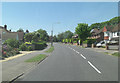
1
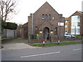
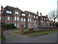
Birkdale Nursery, Bexhill-on-Sea
What was obviously a former chapel is now a day nursery.
Image: © Bill Johnson
Taken: 22 Jan 2008
0.13 miles
2
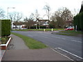
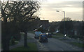
Birkdale, Bexhill-on-Sea
This junction marks a 'boundary' between Collington and the posher reaches of west Bexhill.
Image: © Bill Johnson
Taken: 22 Jan 2008
0.19 miles
3
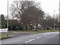
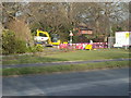
Collington Avenue turns into Birk Dale, Bexhill
Image: © nick macneill
Taken: 7 Dec 2010
0.19 miles
4
Collington Avenue north of Collington Wood
As the road bends right it becomes Birkdale.
Image: © Stuart Logan
Taken: 27 May 2012
0.22 miles