IMAGES TAKEN NEAR TO
TN39 3FU
Introduction
This page details the photographs taken nearby to TN39 3FU by members of the Geograph project.
The Geograph project started in 2005 with the aim of publishing, organising and preserving representative images for every square kilometre of Great Britain, Ireland and the Isle of Man.

There are currently over 7.5m images from over14,400 individuals and you can help contribute to the project by visiting https://www.geograph.org.uk
Image Map
Images are licensed for reuse under creativecommons.org/licenses/by-sa/2.0
Notes
- Clicking on the map will re-center to the selected point.
- The higher the marker number, the further away the image location is from the centre of the postcode.
Image Listing (87 Images Found)
Images are licensed for reuse under creativecommons.org/licenses/by-sa/2.0
Image
Details
Distance
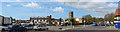
1
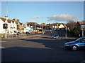
King Offa Way, Bexhill-on-Sea
The main road which was originally intended to be a by-pass to the town centre avoiding the ancient Old Town.
Discussions continue for the need for a proper by-pass for coastal traffic.
Image: © Bill Johnson
Taken: 30 Jan 2008
0.03 miles
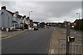
5
A259 junction
Belle Hill and Little Common Road.
Image: © Oast House Archive
Taken: 12 May 2013
0.05 miles
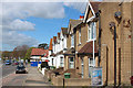
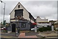
6
Former Double Dragon Chinese Restaurant
Image: © Oast House Archive
Taken: 12 May 2013
0.05 miles
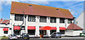
9
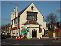
Chinese Restaurant, Bexhill-on-Sea
A former chapel, cum any use which could be found for it, and now a Chinese restaurant at one of the busiest crossroads in Bexhill.
Image: © Bill Johnson
Taken: 30 Jan 2008
0.06 miles
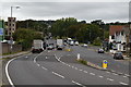
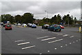
10
London Road junction
At the end of London Road hoarding and scaffolding around the houses to the left ready for demolition for the Bexhill end of the Hastings-Bexhill Link road.
Image: © Oast House Archive
Taken: 12 May 2013
0.06 miles