IMAGES TAKEN NEAR TO
Stable Mews, BEXHILL-ON-SEA, TN39 3FP
Introduction
This page details the photographs taken nearby to Stable Mews, TN39 3FP by members of the Geograph project.
The Geograph project started in 2005 with the aim of publishing, organising and preserving representative images for every square kilometre of Great Britain, Ireland and the Isle of Man.

There are currently over 7.5m images from over14,400 individuals and you can help contribute to the project by visiting https://www.geograph.org.uk
Image Map (Loading...)


Getting Data...Please wait
Leaflet Map data © OpenStreetMap
Images are licensed for reuse under creativecommons.org/licenses/by-sa/2.0
Notes
- Clicking on the map will re-center to the selected point.
- The higher the marker number, the further away the image location is from the centre of the postcode.
Image Listing (86 Images Found)
Images are licensed for reuse under creativecommons.org/licenses/by-sa/2.0
Image
Details
Distance
1
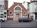
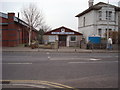
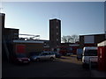
Former Salvation Army Citadel, Bexhill-on-Sea
Now a health and fitness centre
Image: © Bill Johnson
Taken: 14 Feb 2008
0.02 miles
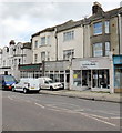
4
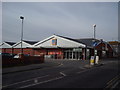
Girl Guide Headquarters, Bexhill-on-Sea
Image: © Bill Johnson
Taken: 14 Feb 2008
0.04 miles
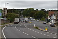
9
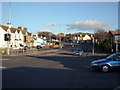
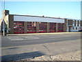
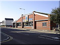
King Offa Way, Bexhill-on-Sea
The main road which was originally intended to be a by-pass to the town centre avoiding the ancient Old Town.
Discussions continue for the need for a proper by-pass for coastal traffic.
Image: © Bill Johnson
Taken: 30 Jan 2008
0.10 miles