IMAGES TAKEN NEAR TO
Juniper Close, ST. LEONARDS-ON-SEA, TN38 9RW
Introduction
This page details the photographs taken nearby to Juniper Close, TN38 9RW by members of the Geograph project.
The Geograph project started in 2005 with the aim of publishing, organising and preserving representative images for every square kilometre of Great Britain, Ireland and the Isle of Man.

There are currently over 7.5m images from over14,400 individuals and you can help contribute to the project by visiting https://www.geograph.org.uk
Image Map
Images are licensed for reuse under creativecommons.org/licenses/by-sa/2.0
Notes
- Clicking on the map will re-center to the selected point.
- The higher the marker number, the further away the image location is from the centre of the postcode.
Image Listing (63 Images Found)
Images are licensed for reuse under creativecommons.org/licenses/by-sa/2.0
Image
Details
Distance
1
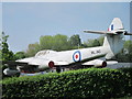
Gloster Meteor WL 345 on Church Wood Drive
At a car sales forecourt, the disused plane is on a post by Church Wood Drive.
The plane is a T7 trainer version, for more information http://en.wikipedia.org/wiki/Gloster_Meteor
Image: © Oast House Archive
Taken: 24 Apr 2011
0.05 miles
2
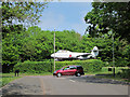
Gloster Meteor WL 345 on Church Wood Drive
Looking from Juniper Close. The disused plane is on a post at a car sales forecourt.
The plane is a T7 trainer version, for more information http://en.wikipedia.org/wiki/Gloster_Meteor
Image: © Oast House Archive
Taken: 24 Apr 2011
0.05 miles
3

Gloster Meteor WL 345 on Church Wood Drive
At a car sales forecourt, the disused plane is on a post by Church Wood Drive.
The plane is a T7 trainer version, for more information http://en.wikipedia.org/wiki/Gloster_Meteor
Image: © Oast House Archive
Taken: 24 Apr 2011
0.05 miles
4
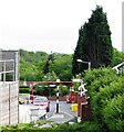
View from Tesco to Church Wood, Hollington
A clutter of street furniture around the exit/entrance to Tesco from Church Wood Drive looking towards Church Wood
Image: © Patrick Roper
Taken: 19 May 2012
0.12 miles

6
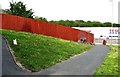
Fence, grass and paths near Tesco, Hollington
On the western side of the Tesco supermarket. Paths leading to Coneyburrow and Ingleside.
Image: © Patrick Roper
Taken: 19 May 2012
0.17 miles
7
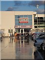
Decks, Tesco
Newly rebranded restaurant and café.
Image: © Oast House Archive
Taken: 11 Oct 2014
0.17 miles
8
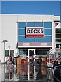
Decks, Tesco
Newly rebranded restaurant and café.
Image: © Oast House Archive
Taken: 11 Oct 2014
0.17 miles
9

Tesco Extra, Hollington
Tesco 'Hastings'.
Image: © Oast House Archive
Taken: 21 Mar 2012
0.18 miles
10

Tesco Extra, Churchwood Drive, St Leonards, East Sussex
Or 'Tesco Hastings' as it is also known. On opening day.
Also see night shot http://www.geograph.org.uk/photo/1066202
Image: © Oast House Archive
Taken: 1 Dec 2008
0.18 miles