IMAGES TAKEN NEAR TO
Norfolk Drive, ST. LEONARDS-ON-SEA, TN38 9QP
Introduction
This page details the photographs taken nearby to Norfolk Drive, TN38 9QP by members of the Geograph project.
The Geograph project started in 2005 with the aim of publishing, organising and preserving representative images for every square kilometre of Great Britain, Ireland and the Isle of Man.

There are currently over 7.5m images from over14,400 individuals and you can help contribute to the project by visiting https://www.geograph.org.uk
Image Map (Loading...)


Getting Data...Please wait
Leaflet Map data © OpenStreetMap
Images are licensed for reuse under creativecommons.org/licenses/by-sa/2.0
Notes
- Clicking on the map will re-center to the selected point.
- The higher the marker number, the further away the image location is from the centre of the postcode.
Image Listing (55 Images Found)
Images are licensed for reuse under creativecommons.org/licenses/by-sa/2.0
Image
Details
Distance
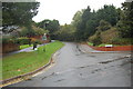
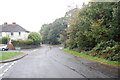
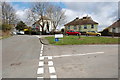
6
Junction of Swynford Drive and Old church Road
Image: © Oliver P Guffogg
Taken: 4 Apr 2010
0.07 miles
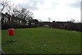
7
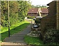
Path from Stirling Road to Lancaster Road
A public footpath from the Tilekiln part of the Castleham Industrial Estate in St Leonards-on-Sea to the residential areas to the south
Image: © Patrick Roper
Taken: 3 Sep 2012
0.07 miles

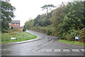
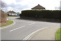
10
Junction of Willingdon Ave and Old Church Road
Image: © Oliver P Guffogg
Taken: 4 Apr 2010
0.10 miles