IMAGES TAKEN NEAR TO
Willingdon Avenue, ST. LEONARDS-ON-SEA, TN38 9HE
Introduction
This page details the photographs taken nearby to Willingdon Avenue, TN38 9HE by members of the Geograph project.
The Geograph project started in 2005 with the aim of publishing, organising and preserving representative images for every square kilometre of Great Britain, Ireland and the Isle of Man.

There are currently over 7.5m images from over14,400 individuals and you can help contribute to the project by visiting https://www.geograph.org.uk
Image Map (Loading...)


Getting Data...Please wait
Leaflet Map data © OpenStreetMap
Images are licensed for reuse under creativecommons.org/licenses/by-sa/2.0
Notes
- Clicking on the map will re-center to the selected point.
- The higher the marker number, the further away the image location is from the centre of the postcode.
Image Listing (65 Images Found)
Images are licensed for reuse under creativecommons.org/licenses/by-sa/2.0
Image
Details
Distance
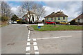
1
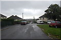
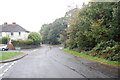
Willingdon Avenue, North part
At Junction with Old Church Road
Image: © Oliver P Guffogg
Taken: 5 Oct 2008
0.03 miles
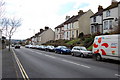
5
Junction of Willingdon Ave and Old Church Road
Image: © Oliver P Guffogg
Taken: 4 Apr 2010
0.05 miles
6
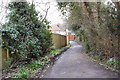
Path from Willingdon Ave to Battle road
Image: © Oliver P Guffogg
Taken: 4 Apr 2010
0.06 miles
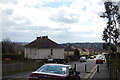
8
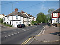
Battle Road
The B2159, heading uphill out of Hollington towards Battle.
Image: © Oast House Archive
Taken: 24 Apr 2011
0.07 miles
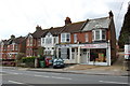
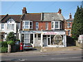
10
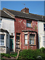
Derelict house on Battle Road
Part of a terrace of houses along the A2159.
See Image
Image: © Oast House Archive
Taken: 24 Apr 2011
0.07 miles