IMAGES TAKEN NEAR TO
Bristol Road, ST. LEONARDS-ON-SEA, TN38 9EW
Introduction
This page details the photographs taken nearby to Bristol Road, TN38 9EW by members of the Geograph project.
The Geograph project started in 2005 with the aim of publishing, organising and preserving representative images for every square kilometre of Great Britain, Ireland and the Isle of Man.

There are currently over 7.5m images from over14,400 individuals and you can help contribute to the project by visiting https://www.geograph.org.uk
Image Map (59 Images)


Getting Data...Please wait
Leaflet Map data © OpenStreetMap
Images are licensed for reuse under creativecommons.org/licenses/by-sa/2.0
Notes
- Clicking on the map will re-center to the selected point.
- The higher the marker number, the further away the image location is from the centre of the postcode.
Image Listing (59 Images Found)
Images are licensed for reuse under creativecommons.org/licenses/by-sa/2.0
Image
Details
Distance
1
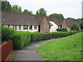
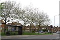
Bristol Road, Hollington
The prefabs have long gone. The pattern of the concrete road slabs, the drain and inspection cover still remain.
Image: © Harold Dilworth Crewdson
Taken: Unknown
0.06 miles
2
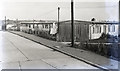
12-14 Bristol Road, St Leonards-on-Sea
Image: © Harold Dilworth Crewdson
Taken: Unknown
0.07 miles
7
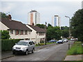
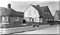
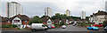
Oxford Road
Stonehouse Drive Tower blocks to the background.
Image: © Oast House Archive
Taken: 19 Jul 2014
0.13 miles
8
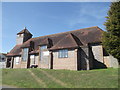
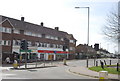
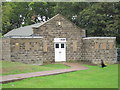
St Anne's Church, Hollington (2)
On Chambers Road.
Image: © David Anstiss
Taken: 6 Apr 2012
0.14 miles
9
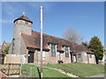
St Anne's Church, Hollington
On Chambers Road.
Image: © David Anstiss
Taken: 6 Apr 2012
0.15 miles