IMAGES TAKEN NEAR TO
Hollington Old Lane, ST. LEONARDS-ON-SEA, TN38 9DU
Introduction
This page details the photographs taken nearby to Hollington Old Lane, TN38 9DU by members of the Geograph project.
The Geograph project started in 2005 with the aim of publishing, organising and preserving representative images for every square kilometre of Great Britain, Ireland and the Isle of Man.

There are currently over 7.5m images from over14,400 individuals and you can help contribute to the project by visiting https://www.geograph.org.uk
Image Map (Loading...)


Getting Data...Please wait
Leaflet Map data © OpenStreetMap
Images are licensed for reuse under creativecommons.org/licenses/by-sa/2.0
Notes
- Clicking on the map will re-center to the selected point.
- The higher the marker number, the further away the image location is from the centre of the postcode.
Image Listing (74 Images Found)
Images are licensed for reuse under creativecommons.org/licenses/by-sa/2.0
Image
Details
Distance
1
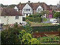
Development site in Coventry Road, Hollington
The 'mock tudor' houses are number 3 and 4 Coventry Road and the photo was taken from Hollington Old Lane. The new development was 2 Coventry Road, now a row of terraced houses.
Image: © Patrick Roper
Taken: 24 Aug 2004
0.02 miles
2

Autumn lady's-tresses, Coventry Road, Hollington
This small orchid (Spiranthes spiralis) was growing on a neglected lawn in a front garden in Coventry Road, possibly imported with turf when the lawn was originally laid. It is a species that has declined considerably over the last century mainly due to changes in land use
Image: © Patrick Roper
Taken: 24 Aug 2004
0.02 miles

4
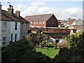
Houses and gardens in Hollington Old Lane
The modern block in the centre of the picture is in Coventry Road.
Image: © Patrick Roper
Taken: 5 Sep 2006
0.02 miles

6
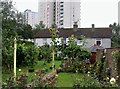
Gardens and houses in Hollington Old Lane, Hastings
The tower blocks in the background are Bevin Court, Kennedy Court, Churchill Court and Roosevelt Court built in 1966.
Image: © Patrick Roper
Taken: 24 Aug 2004
0.04 miles
7

Spur and footpath from Hollington Old Lane to Battle Road
This is the north-eastern end of the public footpath that leads, by the Hollington Stream, from halfway along Blackman Avenue via the steps towards the rear of the picture to Battle Road (B2159).
Image: © Patrick Roper
Taken: 25 Jul 2003
0.04 miles
9
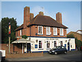
Rising Sun, Hollington
A Shepherd Neame pub on Battle Road.
Image: © Oast House Archive
Taken: 31 Aug 2010
0.05 miles
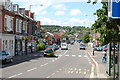
10
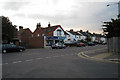
Shops & Houses, Battle Road, Hollington, East Sussex
Image: © Oast House Archive
Taken: 22 Sep 2008
0.06 miles