IMAGES TAKEN NEAR TO
Drury Lane, ST. LEONARDS-ON-SEA, TN38 9BA
Introduction
This page details the photographs taken nearby to Drury Lane, TN38 9BA by members of the Geograph project.
The Geograph project started in 2005 with the aim of publishing, organising and preserving representative images for every square kilometre of Great Britain, Ireland and the Isle of Man.

There are currently over 7.5m images from over14,400 individuals and you can help contribute to the project by visiting https://www.geograph.org.uk
Image Map (Loading...)


Getting Data...Please wait
Leaflet Map data © OpenStreetMap
Images are licensed for reuse under creativecommons.org/licenses/by-sa/2.0
Notes
- Clicking on the map will re-center to the selected point.
- The higher the marker number, the further away the image location is from the centre of the postcode.
Image Listing (38 Images Found)
Images are licensed for reuse under creativecommons.org/licenses/by-sa/2.0
Image
Details
Distance
3
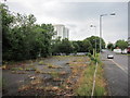
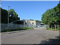
Disused car park, Menzies Road
Former Hastings Borough Council planning offices car park.
Image: © Oast House Archive
Taken: 19 Jul 2014
0.09 miles
5
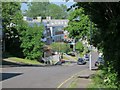
Warehouse at end of Menzies Road
Image: © Oast House Archive
Taken: 15 Jun 2017
0.10 miles
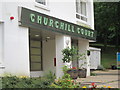
8
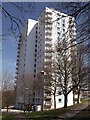
Churchill Court, Hastings
One of the Hollington Tower Blocks on Stonehouse Drive.
Image: © David Anstiss
Taken: 6 Apr 2012
0.13 miles
10
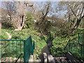
Hollington Stream
As seen from Stonehouse Drive.
Image: © David Anstiss
Taken: 6 Apr 2012
0.14 miles