IMAGES TAKEN NEAR TO
Bexhill Road, ST. LEONARDS-ON-SEA, TN38 8AH
Introduction
This page details the photographs taken nearby to Bexhill Road, TN38 8AH by members of the Geograph project.
The Geograph project started in 2005 with the aim of publishing, organising and preserving representative images for every square kilometre of Great Britain, Ireland and the Isle of Man.

There are currently over 7.5m images from over14,400 individuals and you can help contribute to the project by visiting https://www.geograph.org.uk
Image Map
Images are licensed for reuse under creativecommons.org/licenses/by-sa/2.0
Notes
- Clicking on the map will re-center to the selected point.
- The higher the marker number, the further away the image location is from the centre of the postcode.
Image Listing (104 Images Found)
Images are licensed for reuse under creativecommons.org/licenses/by-sa/2.0
Image
Details
Distance
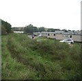
1
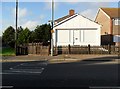
Converted shop, Bexhill Road, Bulverhythe
Image: © nick macneill
Taken: 9 Nov 2011
0.03 miles
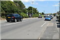
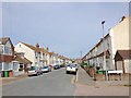
3
Bexhill Road, Bulverhythe, 1
Looking west towards Bexhill.
Image: © Jonathan Billinger
Taken: 9 Jul 2015
0.04 miles
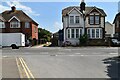
4
Bulverhythe Road, St. Leonards-on-Sea
Image: © Chris Whippet
Taken: 10 Jun 2016
0.06 miles
5
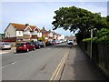
Bulverhythe Road, St. Leonards-on-Sea
Image: © Chris Whippet
Taken: 10 Jun 2016
0.06 miles


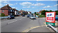
9
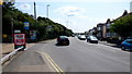
Bexhill Road, Bulverhythe, 2
Looking east towards St. Leonards and Hastings.
Image: © Jonathan Billinger
Taken: 9 Jul 2015
0.07 miles