IMAGES TAKEN NEAR TO
West Hill Road, ST. LEONARDS-ON-SEA, TN38 0ND
Introduction
This page details the photographs taken nearby to West Hill Road, TN38 0ND by members of the Geograph project.
The Geograph project started in 2005 with the aim of publishing, organising and preserving representative images for every square kilometre of Great Britain, Ireland and the Isle of Man.

There are currently over 7.5m images from over14,400 individuals and you can help contribute to the project by visiting https://www.geograph.org.uk
Image Map (Loading...)


Getting Data...Please wait
Leaflet Map data © OpenStreetMap
Images are licensed for reuse under creativecommons.org/licenses/by-sa/2.0
Notes
- Clicking on the map will re-center to the selected point.
- The higher the marker number, the further away the image location is from the centre of the postcode.
Image Listing (169 Images Found)
Images are licensed for reuse under creativecommons.org/licenses/by-sa/2.0
Image
Details
Distance
6
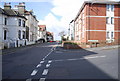
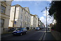
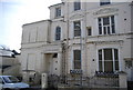
Sovereign Mansions, West Hill Rd
In bedsit land.
Image: © N Chadwick
Taken: 11 Mar 2011
0.05 miles
7
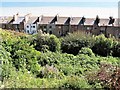
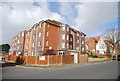
Rear of houses in Marina seen from West Hill Road
These houses look very smart when seen from the front. The vegetation in the foreground is on what must have been the old cliff line. The English Channel lies beyond.
Image: © Patrick Roper
Taken: 20 Jun 2007
0.06 miles
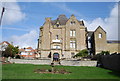
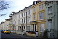
9
St Leonards Mansions
Converted to flats, bedsit land!
Image: © N Chadwick
Taken: 11 Mar 2011
0.07 miles
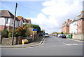
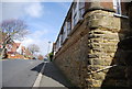
10
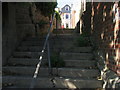
Top of Sussex Steps leading to West Hill Road, St Leonards
These steps used to run all the way down to the sea front but the lower part was closed following a cliff fall in 2002.
Image: © Patrick Roper
Taken: 20 Jun 2007
0.08 miles