IMAGES TAKEN NEAR TO
Upper Maze Hill, ST. LEONARDS-ON-SEA, TN38 0LQ
Introduction
This page details the photographs taken nearby to Upper Maze Hill, TN38 0LQ by members of the Geograph project.
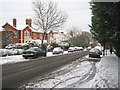
The Geograph project started in 2005 with the aim of publishing, organising and preserving representative images for every square kilometre of Great Britain, Ireland and the Isle of Man.

There are currently over 7.5m images from over14,400 individuals and you can help contribute to the project by visiting https://www.geograph.org.uk
Image Map (Loading...)


Getting Data...Please wait
Leaflet Map data © OpenStreetMap
Images are licensed for reuse under creativecommons.org/licenses/by-sa/2.0
Notes
- Clicking on the map will re-center to the selected point.
- The higher the marker number, the further away the image location is from the centre of the postcode.
Image Listing (67 Images Found)
Images are licensed for reuse under creativecommons.org/licenses/by-sa/2.0
Image
Details
Distance
2
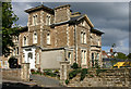
Healey House, Upper Maze Hill, St Leonards
Healey House is a care home owned by the Hastings & Rother Voluntary Association for the Blind. Formerly Clone House, it was one of a number of substantial villas built in the mid-C19 by Decimus Burton.
Image: © David Kemp
Taken: 25 Sep 2010
0.05 miles
3

Du Cros House
Two blocks of seven flats in each. Built c2007 on the site of Levetleigh, which was destroyed after an attack by Suffragettes in 1913.
Image: © Leon Pettit
Taken: 23 Feb 2021
0.09 miles
4

Brittany Road
Residential road looking heading towards Upper Maze Hill. St John's Church -The Evangelist in the background.
Image: © Leon Pettit
Taken: 23 Feb 2021
0.10 miles
5

Finch Mansions
Block of 38 flats located on Upper Maze Hill.
Image: © Leon Pettit
Taken: 23 Feb 2021
0.11 miles
6
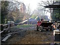
Construction site behind 13/14 Dane Road
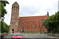
Development work in St Leonards-on-Sea. The tower in the distance is part of St John the Evangelist church, the main surviving structural feature of Arthur Blomfield's building of 1881, which was severely damaged by bombing in 1943.
Image: © Patrick Roper
Taken: 25 Dec 2003
0.11 miles
8
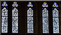
West window, St John's church, Pevensey road, St Leonards
A 5 light window depicting the Te deum, by Lowndes and Drury, designed by J. Ledger, 1952.
Image: © Julian P Guffogg
Taken: 11 Jan 2015
0.12 miles
9
St Leonards Gardens, North end looking South
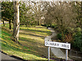
"Originally laid out as a private garden for the Burton family, St Leonards Gardens was bought by the town for £9,000 in 1879. The gardens had two ponds and a maze, which proved very popular and gave Maze Hill its name. Gothic-style buildings were built around the wooded valley. The gateway to St. Leonards Gardens is an imposing Burton building." (information sourced from www.hastings.inuk.com ) The gardens feature Braille name plates for the planting. I am unsure whether this still relates to the planting.
Image: © Simon Hookey
Taken: 4 Mar 2006
0.12 miles