IMAGES TAKEN NEAR TO
Silchester Road, ST. LEONARDS-ON-SEA, TN38 0JF
Introduction
This page details the photographs taken nearby to Silchester Road, TN38 0JF by members of the Geograph project.
The Geograph project started in 2005 with the aim of publishing, organising and preserving representative images for every square kilometre of Great Britain, Ireland and the Isle of Man.

There are currently over 7.5m images from over14,400 individuals and you can help contribute to the project by visiting https://www.geograph.org.uk
Image Map (Loading...)


Getting Data...Please wait
Leaflet Map data © OpenStreetMap
Images are licensed for reuse under creativecommons.org/licenses/by-sa/2.0
Notes
- Clicking on the map will re-center to the selected point.
- The higher the marker number, the further away the image location is from the centre of the postcode.
Image Listing (653 Images Found)
Images are licensed for reuse under creativecommons.org/licenses/by-sa/2.0
Image
Details
Distance
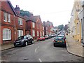
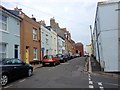
4
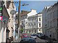
Gensing Road
Three and four storey houses near the centre of St Leonards.
Image: © Oast House Archive
Taken: 10 Apr 2011
0.04 miles
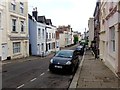
6
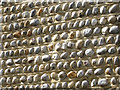
Pebble wall
On the side of a house on Alfred Street.
Image: © Oast House Archive
Taken: 10 Apr 2011
0.05 miles
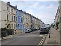
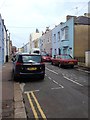
9
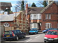
Kenilworth Road
South end of Kenilworth Road, at junction with Gensing Road.
Image: © Oast House Archive
Taken: 10 Apr 2011
0.06 miles