IMAGES TAKEN NEAR TO
Kempton Way, ST. LEONARDS-ON-SEA, TN38 0FU
Introduction
This page details the photographs taken nearby to Kempton Way, TN38 0FU by members of the Geograph project.
The Geograph project started in 2005 with the aim of publishing, organising and preserving representative images for every square kilometre of Great Britain, Ireland and the Isle of Man.

There are currently over 7.5m images from over14,400 individuals and you can help contribute to the project by visiting https://www.geograph.org.uk
Image Map (Loading...)


Getting Data...Please wait
Leaflet Map data © OpenStreetMap
Images are licensed for reuse under creativecommons.org/licenses/by-sa/2.0
Notes
- Clicking on the map will re-center to the selected point.
- The higher the marker number, the further away the image location is from the centre of the postcode.
Image Listing (25 Images Found)
Images are licensed for reuse under creativecommons.org/licenses/by-sa/2.0
Image
Details
Distance
3
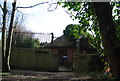
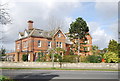
Water pumping station behind Albany Drive
Image: © N Chadwick
Taken: 11 Mar 2011
0.06 miles
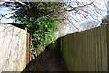
7
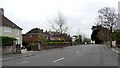
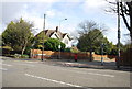
St Leonards on Sea, The Green. The top of Filsham Road.
Image: © Simon Hookey
Taken: 18 Mar 2006
0.11 miles
8
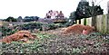
Site clearance off Jubilee Gardens
Crushed brambles and piles of wood chip as this site is prepared for housing development. The large building in the distance is in Gresham Way
Image: © Patrick Roper
Taken: 23 Nov 2012
0.12 miles
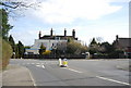
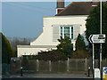
10
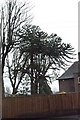
Monkey Puzzle Tree, St Leonards
On the corner of Charles Road West and The Green.
Image: © Julian P Guffogg
Taken: 16 Mar 2013
0.14 miles