IMAGES TAKEN NEAR TO
The Ridge West, ST. LEONARDS-ON-SEA, TN37 7PJ
Introduction
This page details the photographs taken nearby to The Ridge West, TN37 7PJ by members of the Geograph project.
The Geograph project started in 2005 with the aim of publishing, organising and preserving representative images for every square kilometre of Great Britain, Ireland and the Isle of Man.

There are currently over 7.5m images from over14,400 individuals and you can help contribute to the project by visiting https://www.geograph.org.uk
Image Map (Loading...)


Getting Data...Please wait
Leaflet Map data © OpenStreetMap
Images are licensed for reuse under creativecommons.org/licenses/by-sa/2.0
Notes
- Clicking on the map will re-center to the selected point.
- The higher the marker number, the further away the image location is from the centre of the postcode.
Image Listing (143 Images Found)
Images are licensed for reuse under creativecommons.org/licenses/by-sa/2.0
Image
Details
Distance
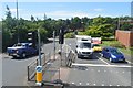
2
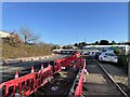
Baldslow Interchange construction
Image: © Oast House Archive
Taken: 1 Dec 2020
0.06 miles

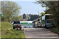
7
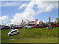
Bartletts SEAT, Seldescombe Road North, St Leonards
Image: © Stacey Harris
Taken: 30 Jun 2012
0.07 miles
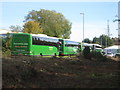
8
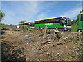
Clearing for new Baldslow Interchange
Coaches parked along Whitworth Road.
Image: © Oast House Archive
Taken: 8 May 2016
0.07 miles
9
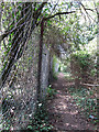
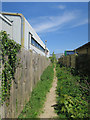
Path and woodland by Whitworth Road
Image: © Oast House Archive
Taken: 23 Apr 2015
0.08 miles
