IMAGES TAKEN NEAR TO
Westfield Lane, ST. LEONARDS-ON-SEA, TN37 7NG
Introduction
This page details the photographs taken nearby to Westfield Lane, TN37 7NG by members of the Geograph project.
The Geograph project started in 2005 with the aim of publishing, organising and preserving representative images for every square kilometre of Great Britain, Ireland and the Isle of Man.

There are currently over 7.5m images from over14,400 individuals and you can help contribute to the project by visiting https://www.geograph.org.uk
Image Map (Loading...)


Getting Data...Please wait
Leaflet Map data © OpenStreetMap
Images are licensed for reuse under creativecommons.org/licenses/by-sa/2.0
Notes
- Clicking on the map will re-center to the selected point.
- The higher the marker number, the further away the image location is from the centre of the postcode.
Image Listing (13 Images Found)
Images are licensed for reuse under creativecommons.org/licenses/by-sa/2.0
Image
Details
Distance
1
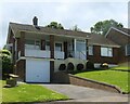
Houses in Maplehirst Close, Baldslow, Hastings
Image: © Patrick Roper
Taken: 8 Jun 2024
0.17 miles
2
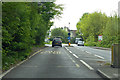
A21 Ebden's Hill
Heading into Hastings.
Image: © Robin Webster
Taken: 30 Apr 2019
0.19 miles

6
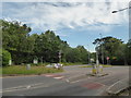
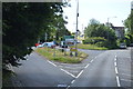
Road junction at Baldslow
(where Maplehurst Road, the A21 and the A28 meet)
Image: © Basher Eyre
Taken: 6 Jul 2019
0.20 miles
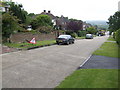
7
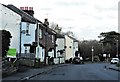
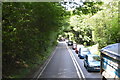
Maplehurst Road, Baldslow, looking north
Formerly part of Harrow Lane.
Image: © Patrick Roper
Taken: 11 Feb 2019
0.21 miles
8
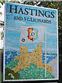
Hastings and St. Leonards sign, A21 Ebden's Hill
Image: © Oast House Archive
Taken: 29 Sep 2012
0.22 miles
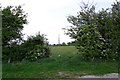
10
Baldslow Down
An elongated cul-de-sac off the A28 to the north of Hastings.
Image: © Jonathan Billinger
Taken: 7 Jun 2007
0.22 miles