IMAGES TAKEN NEAR TO
Sedlescombe Road North, ST. LEONARDS-ON-SEA, TN37 7ET
Introduction
This page details the photographs taken nearby to Sedlescombe Road North, TN37 7ET by members of the Geograph project.
The Geograph project started in 2005 with the aim of publishing, organising and preserving representative images for every square kilometre of Great Britain, Ireland and the Isle of Man.

There are currently over 7.5m images from over14,400 individuals and you can help contribute to the project by visiting https://www.geograph.org.uk
Image Map
Images are licensed for reuse under creativecommons.org/licenses/by-sa/2.0
Notes
- Clicking on the map will re-center to the selected point.
- The higher the marker number, the further away the image location is from the centre of the postcode.
Image Listing (55 Images Found)
Images are licensed for reuse under creativecommons.org/licenses/by-sa/2.0
Image
Details
Distance
5
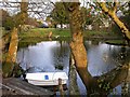
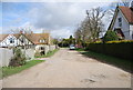
Lake at Gorrick Lodge, Silverhill Avenue
Image: © Patrick Roper
Taken: 24 Feb 2002
0.08 miles
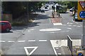
6
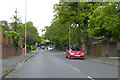
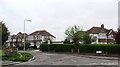
Harrow Lane
Heading north through the suburbs of Hastings.
Image: © Robin Webster
Taken: 30 Apr 2019
0.08 miles
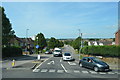
7
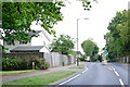
Lower Half of Harrow Lane, St Leonards
Image: © Julian P Guffogg
Taken: 10 May 2008
0.09 miles
8
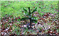
Wet Monkey Puzzle Tree
Too busy watching New Year's concert, so took this in my garden. It was only planted last year.
Image: © Julian P Guffogg
Taken: 1 Jan 2014
0.10 miles
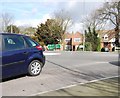
10
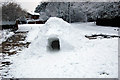
Igloo on Silverhill Avenue
An impressive mound of snow made into an igloo.
Image: © Julian P Guffogg
Taken: 5 Feb 2012
0.10 miles