IMAGES TAKEN NEAR TO
Old Harrow Road, ST. LEONARDS-ON-SEA, TN37 7EG
Introduction
This page details the photographs taken nearby to Old Harrow Road, TN37 7EG by members of the Geograph project.
The Geograph project started in 2005 with the aim of publishing, organising and preserving representative images for every square kilometre of Great Britain, Ireland and the Isle of Man.

There are currently over 7.5m images from over14,400 individuals and you can help contribute to the project by visiting https://www.geograph.org.uk
Image Map (Loading...)


Getting Data...Please wait
Leaflet Map data © OpenStreetMap
Images are licensed for reuse under creativecommons.org/licenses/by-sa/2.0
Notes
- Clicking on the map will re-center to the selected point.
- The higher the marker number, the further away the image location is from the centre of the postcode.
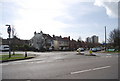
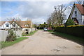
Image Listing (65 Images Found)
Images are licensed for reuse under creativecommons.org/licenses/by-sa/2.0
Image
Details
Distance
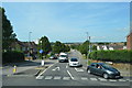
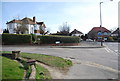
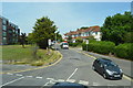
4
Junction of Old Harrow Rd and Mildenhall Drive
Image: © N Chadwick
Taken: 11 Mar 2011
0.09 miles
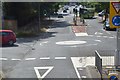
8
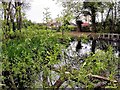
Silverdale Primary School pond, Hollington
The Hollington tower block flats on Stonehouse Drive can be seen in the distance.
Image: © Patrick Roper
Taken: 7 Apr 2002
0.12 miles