IMAGES TAKEN NEAR TO
Old Harrow Road, ST. LEONARDS-ON-SEA, TN37 7ED
Introduction
This page details the photographs taken nearby to Old Harrow Road, TN37 7ED by members of the Geograph project.
The Geograph project started in 2005 with the aim of publishing, organising and preserving representative images for every square kilometre of Great Britain, Ireland and the Isle of Man.

There are currently over 7.5m images from over14,400 individuals and you can help contribute to the project by visiting https://www.geograph.org.uk
Image Map
Images are licensed for reuse under creativecommons.org/licenses/by-sa/2.0
Notes
- Clicking on the map will re-center to the selected point.
- The higher the marker number, the further away the image location is from the centre of the postcode.
Image Listing (78 Images Found)
Images are licensed for reuse under creativecommons.org/licenses/by-sa/2.0
Image
Details
Distance
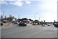
1
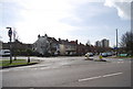
Junction of Old Harrow Rd and Mildenhall Drive
Image: © N Chadwick
Taken: 11 Mar 2011
0.02 miles
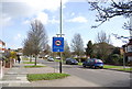
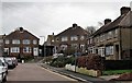
3
Shops & Houses, Battle Road, Hollington, East Sussex
Image: © Oast House Archive
Taken: 22 Sep 2008
0.07 miles
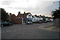
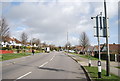
6
Houses at the end of Battle Crescent, Hastings
Battle Crescent is a small cul-de-sac off Battle Road
Image: © Patrick Roper
Taken: 13 Feb 2007
0.10 miles

8
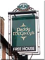
Paddy McGinty's sign
Until 2011 the pub was the known as the Rising Sign.
Also see Image
Image: © Oast House Archive
Taken: 19 Jul 2014
0.10 miles
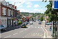
10
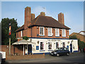
Rising Sun, Hollington
A Shepherd Neame pub on Battle Road.
Image: © Oast House Archive
Taken: 31 Aug 2010
0.11 miles