IMAGES TAKEN NEAR TO
Bohemia Road, ST. LEONARDS-ON-SEA, TN37 6RA
Introduction
This page details the photographs taken nearby to Bohemia Road, TN37 6RA by members of the Geograph project.
The Geograph project started in 2005 with the aim of publishing, organising and preserving representative images for every square kilometre of Great Britain, Ireland and the Isle of Man.

There are currently over 7.5m images from over14,400 individuals and you can help contribute to the project by visiting https://www.geograph.org.uk
Image Map (Loading...)


Getting Data...Please wait
Leaflet Map data © OpenStreetMap
Images are licensed for reuse under creativecommons.org/licenses/by-sa/2.0
Notes
- Clicking on the map will re-center to the selected point.
- The higher the marker number, the further away the image location is from the centre of the postcode.
Image Listing (134 Images Found)
Images are licensed for reuse under creativecommons.org/licenses/by-sa/2.0
Image
Details
Distance
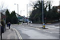
3
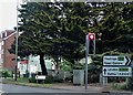
Island at junction of A21 and A2102 in Bohemia
This busy junction has a large island planted with trees that are mature. It has recently (2019) been given a makeover.
Image: © Patrick Roper
Taken: 17 May 2019
0.05 miles
5
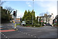
Bohemia junction (A21 & A2102) from the South
Image: © N Chadwick
Taken: 4 Mar 2009
0.05 miles
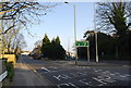
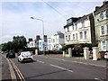
7
The junction of the A21 & A2102
One road goes to Hastings (A21) the other St Leonards
Image: © N Chadwick
Taken: 4 Mar 2009
0.05 miles