IMAGES TAKEN NEAR TO
Eversfield Place, ST. LEONARDS-ON-SEA, TN37 6QP
Introduction
This page details the photographs taken nearby to Eversfield Place, TN37 6QP by members of the Geograph project.
The Geograph project started in 2005 with the aim of publishing, organising and preserving representative images for every square kilometre of Great Britain, Ireland and the Isle of Man.

There are currently over 7.5m images from over14,400 individuals and you can help contribute to the project by visiting https://www.geograph.org.uk
Image Map
Images are licensed for reuse under creativecommons.org/licenses/by-sa/2.0
Notes
- Clicking on the map will re-center to the selected point.
- The higher the marker number, the further away the image location is from the centre of the postcode.
Image Listing (659 Images Found)
Images are licensed for reuse under creativecommons.org/licenses/by-sa/2.0
Image
Details
Distance
2
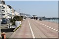
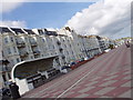
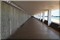
Eversfield Place
Seafront promenade between Hastings and St Leonards.
Image: © Oast House Archive
Taken: 25 Dec 2010
0.03 miles
3
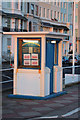
Hastings Weather Station
Actually in St Leonards, this old weather station, from 1875, is on Eversfield Place promenade.
Image: © Oast House Archive
Taken: 27 Oct 2012
0.03 miles
4
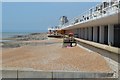
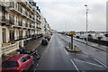
Hastings, seafront architecture
Notice the beautiful bench shelter.
Image: © Matt Baines
Taken: 22 Jul 2007
0.03 miles
8
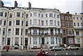
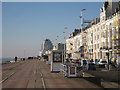
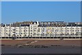
Seafront buildings, Hastings
Most of these have been converted into flats.
Image: © N Chadwick
Taken: 3 May 2010
0.04 miles