IMAGES TAKEN NEAR TO
London Road, ST. LEONARDS-ON-SEA, TN37 6ND
Introduction
This page details the photographs taken nearby to London Road, TN37 6ND by members of the Geograph project.
The Geograph project started in 2005 with the aim of publishing, organising and preserving representative images for every square kilometre of Great Britain, Ireland and the Isle of Man.

There are currently over 7.5m images from over14,400 individuals and you can help contribute to the project by visiting https://www.geograph.org.uk
Image Map (Loading...)


Getting Data...Please wait
Leaflet Map data © OpenStreetMap
Images are licensed for reuse under creativecommons.org/licenses/by-sa/2.0
Notes
- Clicking on the map will re-center to the selected point.
- The higher the marker number, the further away the image location is from the centre of the postcode.
Image Listing (121 Images Found)
Images are licensed for reuse under creativecommons.org/licenses/by-sa/2.0
Image
Details
Distance
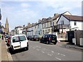
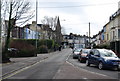
6
Springfield Road, St Leonard's
This road leads from London Road to Sedlescombe Road South.
On the right, are many white houses a predominant colours of houses in Hastings.
Image: © David Anstiss
Taken: 6 Apr 2012
0.05 miles
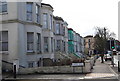
8
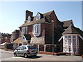
Large house, Buchanan Gardens
Must have had a former use.
Has a clock over the doorway!
Image: © David Anstiss
Taken: 6 Apr 2012
0.05 miles
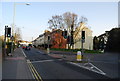
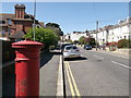
9
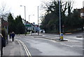
The junction of the A21 & A2102
One road goes to Hastings (A21) the other St Leonards
Image: © N Chadwick
Taken: 4 Mar 2009
0.05 miles
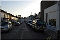
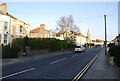
10
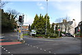
Bohemia junction (A21 & A2102) from the South
Image: © N Chadwick
Taken: 4 Mar 2009
0.06 miles