IMAGES TAKEN NEAR TO
Cloudesley Road, ST. LEONARDS-ON-SEA, TN37 6JN
Introduction
This page details the photographs taken nearby to Cloudesley Road, TN37 6JN by members of the Geograph project.
The Geograph project started in 2005 with the aim of publishing, organising and preserving representative images for every square kilometre of Great Britain, Ireland and the Isle of Man.

There are currently over 7.5m images from over14,400 individuals and you can help contribute to the project by visiting https://www.geograph.org.uk
Image Map (Loading...)


Getting Data...Please wait
Leaflet Map data © OpenStreetMap
Images are licensed for reuse under creativecommons.org/licenses/by-sa/2.0
Notes
- Clicking on the map will re-center to the selected point.
- The higher the marker number, the further away the image location is from the centre of the postcode.
Image Listing (93 Images Found)
Images are licensed for reuse under creativecommons.org/licenses/by-sa/2.0
Image
Details
Distance
1
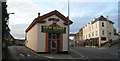
Pizza Hut Delivery, Bohemia Road
A small pizza hut takeaway at junction of Cornfield Terrace (to left).
Image: © Oast House Archive
Taken: 6 Nov 2010
0.06 miles
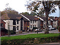
3
Woodland Vale Road houses
Houses and flats at the Southern end of Woodland Vale Road where it joins Southwater Road, St Leonards-on-Sea (2003)
Image: © Patrick Roper
Taken: 7 Apr 2002
0.09 miles
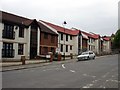
4
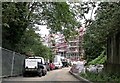
Construction of flats, The Glen off Woodland Vale Road
The Glen is a small area of wilderness and wildlife between Woodland Vale Road and London Road. The house with the rotunda (towards top left) is in Woodland Vale Road
Image: © Patrick Roper
Taken: 26 Aug 2001
0.10 miles
5
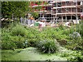
The Glen with development encroaching
The Glen, a small area of wilderness, lies between Woodland Vale Road and London Road
Image: © Patrick Roper
Taken: 26 Aug 2001
0.11 miles
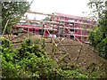
6
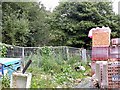
Building materials in The Glen off Woodland Vale Road
Materials to be used in the construction of housing in this small marshy valley between Woodland Vale Road and London Road.
Image: © Patrick Roper
Taken: 26 Aug 2001
0.12 miles
7
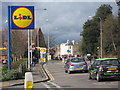
A21 Bohemia Road
Road leading out of Hastings. Lidl supermarket to the left.
Image: © Oast House Archive
Taken: 26 Feb 2011
0.12 miles
8
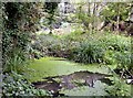
Pond in The Glen near Warrior Square
This small valley between London Road and Woodland Vale Road photographed in 2001 has had its character much altered by encroaching development.
Image: © Patrick Roper
Taken: 26 Aug 2001
0.12 miles
9
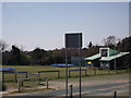
Summerfields Cricket Pavilion
As seen from Image
Image: © David Anstiss
Taken: 6 Apr 2012
0.12 miles
10
Construction of flats, Woodland Vale Road
Seen from The Glen, these flats were being built in 2001.
Image: © Patrick Roper
Taken: 26 Aug 2001
0.13 miles