IMAGES TAKEN NEAR TO
Warrior Square, ST. LEONARDS-ON-SEA, TN37 6BX
Introduction
This page details the photographs taken nearby to Warrior Square, TN37 6BX by members of the Geograph project.
The Geograph project started in 2005 with the aim of publishing, organising and preserving representative images for every square kilometre of Great Britain, Ireland and the Isle of Man.

There are currently over 7.5m images from over14,400 individuals and you can help contribute to the project by visiting https://www.geograph.org.uk
Image Map
Images are licensed for reuse under creativecommons.org/licenses/by-sa/2.0
Notes
- Clicking on the map will re-center to the selected point.
- The higher the marker number, the further away the image location is from the centre of the postcode.
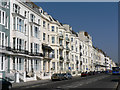
Image Listing (538 Images Found)
Images are licensed for reuse under creativecommons.org/licenses/by-sa/2.0
Image
Details
Distance
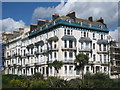
4
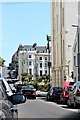
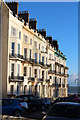
Looking from Warrior Square towards St. Margaret's Road, St Leonard's-on-Sea
Image: © Patrick Roper
Taken: 22 May 2009
0.02 miles
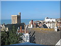
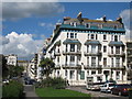
6
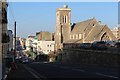
St Margaret's Road
Grade II listed https://historicengland.org.uk/listing/the-list/list-entry/1043430 Church of St Magdalene to the right.
Image: © Oast House Archive
Taken: 12 Mar 2012
0.03 miles
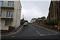
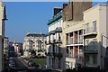
9
Warrior House
At junction of Warrior Square and St Margaret's Road.
Image: © Oast House Archive
Taken: 12 Sep 2010
0.03 miles