IMAGES TAKEN NEAR TO
Harbour Farm, WINCHELSEA, TN36 4LP
Introduction
This page details the photographs taken nearby to Harbour Farm, TN36 4LP by members of the Geograph project.
The Geograph project started in 2005 with the aim of publishing, organising and preserving representative images for every square kilometre of Great Britain, Ireland and the Isle of Man.

There are currently over 7.5m images from over14,400 individuals and you can help contribute to the project by visiting https://www.geograph.org.uk
Image Map (69 Images)


Getting Data...Please wait
Leaflet Map data © OpenStreetMap
Images are licensed for reuse under creativecommons.org/licenses/by-sa/2.0
Notes
- Clicking on the map will re-center to the selected point.
- The higher the marker number, the further away the image location is from the centre of the postcode.
Image Listing (69 Images Found)
Images are licensed for reuse under creativecommons.org/licenses/by-sa/2.0
Image
Details
Distance
2
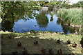
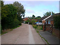
Pond, Willow Lane
Occupying a spot once used as a channel for the new harbour at Rye (See Image for full story), now in land between Sea Road and Harbour Barn.
Image: © Simon Carey
Taken: 2 Aug 2008
0.05 miles
4
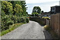
Morlais Ridge
A private road though a public footpath that follows the course of an old sea wall. The land to the right would have been the high water mark around the end of the 16th century.
Image: © Simon Carey
Taken: 2 Aug 2008
0.07 miles
5
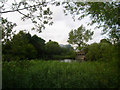
Willow Lane
Small lane between Sea Road and Morlais Ridge that was the site of a drawbridge and sluice gate for the new harbour of Rye (See Image for full story). A small pond is beyond the foliage on the left whilst a small pumping station is to the right which still uses a drain that follows the old course of the harbour channel.
Image: © Simon Carey
Taken: 2 Aug 2008
0.07 miles
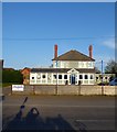
7
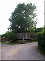
Pill Box, Willow Lane
Next to the entrance of Windmill Park Caravan Site. It would have guarded the access point to Sea Road from across the shingle banks of Rye Harbour.
Image: © Simon Carey
Taken: 2 Aug 2008
0.07 miles
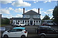
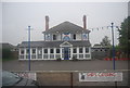
10
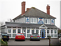
The Ship, Sea Road, Winchelsea Beach
Built in the 1930s to replace an older pub on Pett Level that had been washed into the sea, see Image Ceased being a public house in 2010 and is now a restaurant and cafe bar.
Image: © Simon Carey
Taken: 21 Apr 2019
0.08 miles