IMAGES TAKEN NEAR TO
Windmill Way, WINCHELSEA, TN36 4LF
Introduction
This page details the photographs taken nearby to Windmill Way, TN36 4LF by members of the Geograph project.
The Geograph project started in 2005 with the aim of publishing, organising and preserving representative images for every square kilometre of Great Britain, Ireland and the Isle of Man.

There are currently over 7.5m images from over14,400 individuals and you can help contribute to the project by visiting https://www.geograph.org.uk
Image Map (Loading...)


Getting Data...Please wait
Leaflet Map data © OpenStreetMap
Images are licensed for reuse under creativecommons.org/licenses/by-sa/2.0
Notes
- Clicking on the map will re-center to the selected point.
- The higher the marker number, the further away the image location is from the centre of the postcode.
Image Listing (64 Images Found)
Images are licensed for reuse under creativecommons.org/licenses/by-sa/2.0
Image
Details
Distance
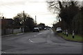
1

Windmill Way, Winchelsea Beach
Grid line runs down the middle of this road meaning the houses on the left are in TQ9117 and Windmill Court on the right is in TQ 9116. The road leads to Morlais Place.
Image: © Simon Carey
Taken: 21 Apr 2019
0.01 miles
3
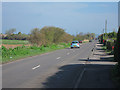
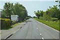
Sea Road
Straight road through Winchelsea Beach.
Image: © Oast House Archive
Taken: 2 Apr 2011
0.05 miles
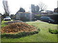
5

The Tun Field
The name of the field according to Icklesham's 1845 tithe map that is located on the eastern side of Dimsdale Sewer.
Image: © Simon Carey
Taken: 1 Jun 2019
0.07 miles
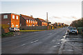
7
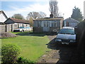
Abandoned House
The house on Sea Road and two Citroën cars appear to have been abandoned, however the lawn appears to be well kept.
Image: © Oast House Archive
Taken: 2 Apr 2011
0.10 miles
8
Abandoned House
The house on Sea Road and two Citroën cars appear to have been abandoned, however the lawn appears to be well kept.
Image: © Oast House Archive
Taken: 2 Apr 2011
0.10 miles
9
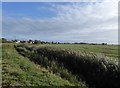
The view from Sea Road
Just in front of the camera but hidden by reeds is an important drainage channel - seen much more clearly (after recent re-excavation) in Simon Carey's contribution: Image Beyond the 'sewer' there is a stretch of drained marshland, and then houses along the final north-south portion of Sea Road.
Image: © Stefan Czapski
Taken: 28 Sep 2016
0.13 miles