IMAGES TAKEN NEAR TO
North Street, WINCHELSEA, TN36 4HR
Introduction
This page details the photographs taken nearby to North Street, TN36 4HR by members of the Geograph project.
The Geograph project started in 2005 with the aim of publishing, organising and preserving representative images for every square kilometre of Great Britain, Ireland and the Isle of Man.

There are currently over 7.5m images from over14,400 individuals and you can help contribute to the project by visiting https://www.geograph.org.uk
Image Map (Loading...)


Getting Data...Please wait
Leaflet Map data © OpenStreetMap
Images are licensed for reuse under creativecommons.org/licenses/by-sa/2.0
Notes
- Clicking on the map will re-center to the selected point.
- The higher the marker number, the further away the image location is from the centre of the postcode.
Image Listing (441 Images Found)
Images are licensed for reuse under creativecommons.org/licenses/by-sa/2.0
Image
Details
Distance
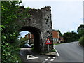
1
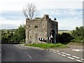
Pipewell Gate
Sometimes known as Landgate. Connects North Street (formerly First Street) with Ferry Hill and was formerly the main land route to Rye via a ferry over the River Brede.
Image: © Simon Carey
Taken: 10 Mar 2007
0.01 miles
3
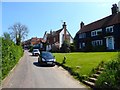
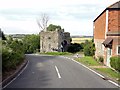
North Street, Winchelsea
Linking Ferry Hill, the A259, to Castle Street. From right to left the houses are Pipewell Cottages, Broad View and Turners.
Image: © Simon Carey
Taken: 24 May 2019
0.02 miles
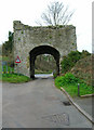
4
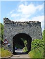
Pipewell Gate, Winchelsea
Dating from 1404 having been rebuilt after the original was destroyed by a Franco-Castilian raid in 1380. Sometimes known as the Ferry Gate due to the proximity of a former ferry that connected Winchelsea to Rye. Located at the junction of North Street and Ferry Hill.
Image: © Simon Carey
Taken: 24 May 2019
0.02 miles
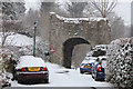
5
Landgate The Pipewell
Grade I listed http://list.english-heritage.org.uk/resultsingle.aspx?uid=1234567 one of three in the village.
Image: © Oast House Archive
Taken: 5 Feb 2012
0.02 miles
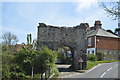
6
A259 passes the Pipewell gate
The Pipewell Gate dates from 1380 and is also known as the North Gate or Land Gate. It was built at the top of Ferry Road to defend access to the town from the ferry across the Brede. Hence it is also known as Ferry Gate.
Image: © Stuart Logan
Taken: 27 May 2012
0.02 miles
7
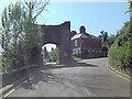
Winchelsea, Ferry Hill
Winchelsea, Ferry Hill, A259, Landgate.
Winchelsea is a small village in East Sussex, England, located between the High Weald and the Romney Marsh, approximately 3 km south west of Rye and 12 km north east of Hastings.
The village stands on the site of a medieval town, founded in 1288, to replace an earlier town of the same name, sometimes known as Old Winchelsea, which was lost to the sea. The village is part of the civil parish of Icklesham.
Image: © Helmut Zozmann
Taken: 30 Jul 2012
0.02 miles
8
Winchelsea, Ferry Hill
Winchelsea, Ferry Hill, A259, Landgate.
Winchelsea is a small village in East Sussex, England, located between the High Weald and the Romney Marsh, approximately 3 km south west of Rye and 12 km north east of Hastings.
The village stands on the site of a medieval town, founded in 1288, to replace an earlier town of the same name, sometimes known as Old Winchelsea, which was lost to the sea. The village is part of the civil parish of Icklesham.
Image: © Helmut Zozmann
Taken: 30 Jul 2012
0.02 miles