IMAGES TAKEN NEAR TO
Mill Road, WINCHELSEA, TN36 4HJ
Introduction
This page details the photographs taken nearby to Mill Road, TN36 4HJ by members of the Geograph project.
The Geograph project started in 2005 with the aim of publishing, organising and preserving representative images for every square kilometre of Great Britain, Ireland and the Isle of Man.

There are currently over 7.5m images from over14,400 individuals and you can help contribute to the project by visiting https://www.geograph.org.uk
Image Map (Loading...)


Getting Data...Please wait
Leaflet Map data © OpenStreetMap
Images are licensed for reuse under creativecommons.org/licenses/by-sa/2.0
Notes
- Clicking on the map will re-center to the selected point.
- The higher the marker number, the further away the image location is from the centre of the postcode.
Image Listing (456 Images Found)
Images are licensed for reuse under creativecommons.org/licenses/by-sa/2.0
Image
Details
Distance
2
School Hill
Looking towards the junction with North Street then over Brede Level towards Cadborough Cliff.
Image: © Simon Carey
Taken: 10 Mar 2007
0.02 miles
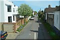
3
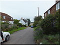
School Hill, Winchelsea
Short street connecting Mill Road to North Street. Ivy Cottages are on the right with Saffron Cottage the white building to the left.
Image: © Simon Carey
Taken: 1 Jun 2019
0.02 miles
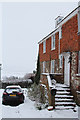
4
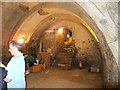
Medieval Cellar under house in Mill Road, Winchelsea
Image: © PAUL FARMER
Taken: 2 Sep 2012
0.02 miles
5
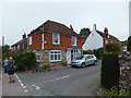
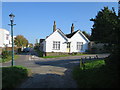
House on corner of Mill Road and School Hill, Winchelsea
The cellar under this house is shown here: http://www.geograph.org.uk/photo/3113561
Image: © PAUL FARMER
Taken: 2 Sep 2012
0.02 miles
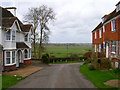
7
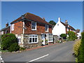
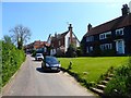
Street scene in Winchelsea
Winchelsea became a member of the Cinque Ports by 1191 along with Rye. Winchelsea at that time lay on the east side of the estuary of the River Rother. A storm damaged the town in 1252, in 1266 the war between the barons and Edward I did further damage, and in 1288 an even greater storm all but wiped out Winchelsea. In 1280, the King had acquired the Manor of Iham to build a new town here which was to be a planned town. Its purpose was to help the wine trade with Gascony with an up-to-date settlement at this end. The plan was to be a grid but the south half which was to have had a town hall and market place was never built.
There were three churches and three hospitals but the town was not a success. By the mid 14th century parts had become vacant, there were several French raids between 1337 and 1380, and in the second half of the 14th century the harbour silted up. The present-day Winchelsea consists of only twelve blocks out of the original thirty nine. The plots were quite large and each house had plenty of space. As a result and in the words of Pevsner in 'The Buildings of England: Sussex' "As the population never grew, the spaces never closed up, and so today Winchelsea with its green grass verges flanking the streets is more like a formally planned garden suburb than like a town."
The medieval parts of the houses are mostly confined to the cellars and in appearance Winchelsea is partly Georgian and partly attractive early 20th century. There is no denying how attractive and peaceful it is, especially compared to the crowds in Rye. In summer flowers are everywhere, especially roses, lavender and fuchsias.
This is looking along Mill Road from the junction with Hiham Green and School Hill.
For more about the history of Winchelsea see https://www.visit1066country.com/destinations/winchelsea/history-of-winchelsea
Image: © Marathon
Taken: 18 Jun 2017
0.03 miles
8
The Five Houses, Winchelsea
Grade II* listed http://list.english-heritage.org.uk/resultsingle.aspx?uid=1234608
Image: © Oast House Archive
Taken: 20 Jan 2013
0.03 miles
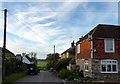
10
North Street, Winchelsea
Linking Ferry Hill, the A259, to Castle Street. From right to left the houses are Pipewell Cottages, Broad View and Turners.
Image: © Simon Carey
Taken: 24 May 2019
0.04 miles