IMAGES TAKEN NEAR TO
Kent Close, WINCHELSEA, TN36 4EX
Introduction
This page details the photographs taken nearby to Kent Close, TN36 4EX by members of the Geograph project.
The Geograph project started in 2005 with the aim of publishing, organising and preserving representative images for every square kilometre of Great Britain, Ireland and the Isle of Man.

There are currently over 7.5m images from over14,400 individuals and you can help contribute to the project by visiting https://www.geograph.org.uk
Image Map
Images are licensed for reuse under creativecommons.org/licenses/by-sa/2.0
Notes
- Clicking on the map will re-center to the selected point.
- The higher the marker number, the further away the image location is from the centre of the postcode.
Image Listing (430 Images Found)
Images are licensed for reuse under creativecommons.org/licenses/by-sa/2.0
Image
Details
Distance
3
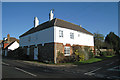
The Oast House, Rectory Lane, Winchelsea, East Sussex
Image: © Oast House Archive
Taken: 6 Dec 2008
0.03 miles

6
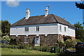
The Oast House, Rectory Lane, Winchelsea
Image: © Oast House Archive
Taken: 6 Jun 2015
0.03 miles
7
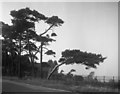
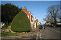
Winchelsea: Trees showing the effect of the prevailing wind
The building in the background is thought to be New Hall, the photograph having been taken on Roberts Hill.
Image: © Dr Neil Clifton
Taken: 18 Mar 2006
0.04 miles
8
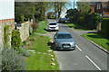
Lamp Post on Monk's Walk, Winchelsea
Image: © Oast House Archive
Taken: 6 Dec 2008
0.04 miles